IMAGES TAKEN NEAR TO
Castle Manor, BALLYCLARE, BT39 9GW
Introduction
This page details the photographs taken nearby to Castle Manor, BT39 9GW by members of the Geograph project.
The Geograph project started in 2005 with the aim of publishing, organising and preserving representative images for every square kilometre of Great Britain, Ireland and the Isle of Man.

There are currently over 7.5m images from over14,400 individuals and you can help contribute to the project by visiting https://www.geograph.org.uk
Image Map
Images are licensed for reuse under creativecommons.org/licenses/by-sa/2.0
Notes
- Clicking on the map will re-center to the selected point.
- The higher the marker number, the further away the image location is from the centre of the postcode.
Image Listing (9 Images Found)
Images are licensed for reuse under creativecommons.org/licenses/by-sa/2.0
Image
Details
Distance
1
Beatties, Ballynure
A very convenient place to stop and get a traditional fish and chip supper.
Image: © Kenneth Allen
Taken: 8 May 2007
0.09 miles
2
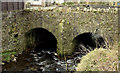
The Ballynure Water, Ballynure (March 2016)
The Ballynure Water, a short tributary of the Sixmilewater, approaching a two-arch stone bridge under the Castle Road. The OS map calls this the “Castle Water” but council publicity material refers to “Ballynure Water”.
Image: © Albert Bridge
Taken: 6 Mar 2016
0.17 miles
4
Ballynure, County Antrim
A quiet little village
Image: © Kenneth Allen
Taken: 8 Apr 2006
0.20 miles
5
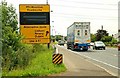
Road sign at Ballynure
During the rebuilding of the Westlink, linking the M2 and M1 in Belfast Image, a (voluntary) diversionary route for through traffic (avoiding Belfast) was signposted for vehicles to and from Larne. This sign is at Ballynure. More or less redundant now with the opening of the underpass at Broadway Image
Image: © Albert Bridge
Taken: 21 Jul 2008
0.20 miles
6
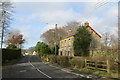
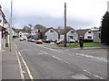
Carrickfergus Road
The B58 Carrickfergus Road ran through Ballynure past this house until recently when a short bypass was built to take it directly to the A8 at the roundabout and junction with the Larne Road and Templepatrick Road, part of the Larne Road upgrade to a dual carriageway.
Image: © Robert Ashby
Taken: 6 Feb 2014
0.20 miles
7
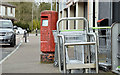
Pillar box (BT39 6), Ballynure (March 2016)
EIIR pillar box outside the Co-Op and post office at Main Street. The number has been covered by a sticker but it should be BT39 6.
Image: © Albert Bridge
Taken: 6 Mar 2016
0.21 miles
8
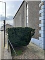
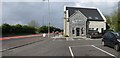
Benchmark on Ballynure Presbyterian Church
Bottom left corner of the halls complex building.
Image: © Erin
Taken: 4 Apr 2023
0.21 miles
9
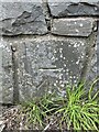
Benchmark on Ballynure Road Bridge
Over the river bridge on the B58
Image: © Erin
Taken: 4 Apr 2023
0.23 miles