IMAGES TAKEN NEAR TO
Henryville Manor, BALLYCLARE, BT39 9FP
Introduction
This page details the photographs taken nearby to Henryville Manor, BT39 9FP by members of the Geograph project.
The Geograph project started in 2005 with the aim of publishing, organising and preserving representative images for every square kilometre of Great Britain, Ireland and the Isle of Man.

There are currently over 7.5m images from over14,400 individuals and you can help contribute to the project by visiting https://www.geograph.org.uk
Image Map
Images are licensed for reuse under creativecommons.org/licenses/by-sa/2.0
Notes
- Clicking on the map will re-center to the selected point.
- The higher the marker number, the further away the image location is from the centre of the postcode.
Image Listing (3 Images Found)
Images are licensed for reuse under creativecommons.org/licenses/by-sa/2.0
Image
Details
Distance
1
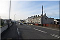
The suburbs of Ballyclare
Looking along the Ballynure Road towards the centre of Ballyclare.
Image: © Robert Ashby
Taken: 6 Feb 2014
0.08 miles
2
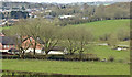
Houses and fields, Ballyclare (March 2016)
In common with most towns within easy commuting distances of Belfast, Ballyclare has expanded well beyond its original boundary. In this case the housing, on the north eastern side, has almost reached the Sixmilewater (middle right). The view is from this stretch of the Templepatrick Road Image
Image: © Albert Bridge
Taken: 6 Mar 2016
0.13 miles
3
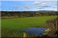
Waterlogged field
View across a sodden field beside the Templepatrick Road at Ballyclare towards Ballyboley Forest just visible on the distant hilltop to the right.
Image: © Robert Ashby
Taken: 6 Feb 2014
0.21 miles