IMAGES TAKEN NEAR TO
Dixons Corner, BALLYCLARE, BT39 0UF
Introduction
This page details the photographs taken nearby to Dixons Corner, BT39 0UF by members of the Geograph project.
The Geograph project started in 2005 with the aim of publishing, organising and preserving representative images for every square kilometre of Great Britain, Ireland and the Isle of Man.

There are currently over 7.5m images from over14,400 individuals and you can help contribute to the project by visiting https://www.geograph.org.uk
Image Map
Images are licensed for reuse under creativecommons.org/licenses/by-sa/2.0
Notes
- Clicking on the map will re-center to the selected point.
- The higher the marker number, the further away the image location is from the centre of the postcode.
Image Listing (6 Images Found)
Images are licensed for reuse under creativecommons.org/licenses/by-sa/2.0
Image
Details
Distance
1
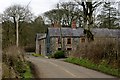
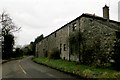
Orpinsmill Road
Attractive renovated stone cottages, which possibly once housed the workers in the nearby Walkmill.
Image: © Robert Ashby
Taken: 12 Feb 2015
0.01 miles
4
Brookfield Road
An old mill, marked on my O.S. map as Walkmill or possibly Orpin's Mill.
Image: © Robert Ashby
Taken: 12 Feb 2015
0.05 miles