IMAGES TAKEN NEAR TO
Moyra Road, BALLYCLARE, BT39 0SD
Introduction
This page details the photographs taken nearby to Moyra Road, BT39 0SD by members of the Geograph project.
The Geograph project started in 2005 with the aim of publishing, organising and preserving representative images for every square kilometre of Great Britain, Ireland and the Isle of Man.

There are currently over 7.5m images from over14,400 individuals and you can help contribute to the project by visiting https://www.geograph.org.uk
Image Map
Images are licensed for reuse under creativecommons.org/licenses/by-sa/2.0
Notes
- Clicking on the map will re-center to the selected point.
- The higher the marker number, the further away the image location is from the centre of the postcode.
Image Listing (3 Images Found)
Images are licensed for reuse under creativecommons.org/licenses/by-sa/2.0
Image
Details
Distance
1
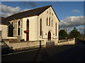
Kilbride Presbyterian Church
Kilbride Presbyterian Church on the Moyra Road, Burnside, North of Ballyclare and Doagh.
Image: © Puffer
Taken: 14 Jan 2012
0.03 miles
2
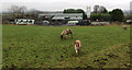
Douglasland Road
Three dejected looking horses grazing in a somewhat muddy field beside the Douglasland Road near Doagh. It was a gloomy and wet winters day.
Image: © Robert Ashby
Taken: 8 Dec 2013
0.19 miles
3
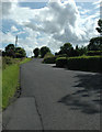
The"Greystone"
A hill on the Moyra Road
Image: © Darryl Bowden
Taken: 15 Jul 2009
0.22 miles