IMAGES TAKEN NEAR TO
Mill Road, BALLYCLARE, BT39 0PQ
Introduction
This page details the photographs taken nearby to Mill Road, BT39 0PQ by members of the Geograph project.
The Geograph project started in 2005 with the aim of publishing, organising and preserving representative images for every square kilometre of Great Britain, Ireland and the Isle of Man.

There are currently over 7.5m images from over14,400 individuals and you can help contribute to the project by visiting https://www.geograph.org.uk
Image Map
Images are licensed for reuse under creativecommons.org/licenses/by-sa/2.0
Notes
- Clicking on the map will re-center to the selected point.
- The higher the marker number, the further away the image location is from the centre of the postcode.
Image Listing (6 Images Found)
Images are licensed for reuse under creativecommons.org/licenses/by-sa/2.0
Image
Details
Distance
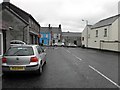
1
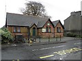
Former Primary School, Doagh
It is located in the centre of the village; see close-up of plaque here Image]
Image: © Kenneth Allen
Taken: 17 Nov 2009
0.14 miles
2
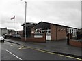
Doagh Primary School
It replaces the former school on the opposite side of the road
Image: © Kenneth Allen
Taken: 17 Nov 2009
0.18 miles
3
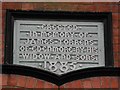
Plaque, Doagh School
It is located here Image]
Image: © Kenneth Allen
Taken: 17 Nov 2009
0.20 miles
4
Corner stone, Doagh
We had a similar one in Omagh called the "Bull's eye" - see Image]
Image: © Kenneth Allen
Taken: 17 Nov 2009
0.21 miles
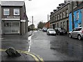
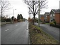
5
Ballymena Road, Doagh
Looking east towards the main road at the village centre
Image: © Kenneth Allen
Taken: 17 Nov 2009
0.22 miles
6
B59, Ballymena Road
Heading east towards Doagh
Image: © Kenneth Allen
Taken: 17 Nov 2009
0.23 miles