IMAGES TAKEN NEAR TO
The Grange, BALLYCLARE, BT39 0JL
Introduction
This page details the photographs taken nearby to The Grange, BT39 0JL by members of the Geograph project.
The Geograph project started in 2005 with the aim of publishing, organising and preserving representative images for every square kilometre of Great Britain, Ireland and the Isle of Man.

There are currently over 7.5m images from over14,400 individuals and you can help contribute to the project by visiting https://www.geograph.org.uk
Image Map
Images are licensed for reuse under creativecommons.org/licenses/by-sa/2.0
Notes
- Clicking on the map will re-center to the selected point.
- The higher the marker number, the further away the image location is from the centre of the postcode.
Image Listing (9 Images Found)
Images are licensed for reuse under creativecommons.org/licenses/by-sa/2.0
Image
Details
Distance
1
Burn Road
New houses under construction to the east of Parkgate.
Image: © Robert Ashby
Taken: 5 Nov 2014
0.07 miles
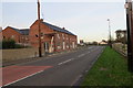
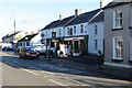
2
The Burn Road
Houses on the Burn Road at Parkgate.
Image: © Robert Ashby
Taken: 17 Oct 2013
0.08 miles
3
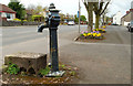
Old pump, Parkgate (1)
An old pump, with handle, in Main Street.
Image: © Albert Bridge
Taken: 14 Apr 2011
0.17 miles
4
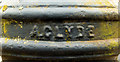
Old pump, Parkgate (2)
See Image The inscription showing that it was made by A Clyde (Successors) Limited – a business which traded from Ballymena.
Image: © Albert Bridge
Taken: 14 Apr 2011
0.17 miles
5
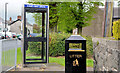
Telephone box and litter bin, Parkgate
Telephone box and litter bin at Main Street, close to the Connor Road.
Image: © Albert Bridge
Taken: 1 Jun 2013
0.20 miles
6
Parkgate, County Antrim
Looking south-east on the Connor Road
Image: © Kenneth Allen
Taken: 13 Nov 2009
0.21 miles
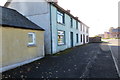
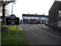
7
Parkgate Village
Houses and shops in Parkgate.
Image: © Robert Ashby
Taken: 17 Oct 2013
0.23 miles
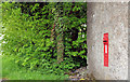
8
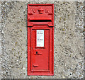
Victorian wall box, Parkgate (1)
A VR wall box on the Burn Road (to/from Templepatrick), Parkgate. The number BT39 139 is clearly visible in the original photograph. According to the Royal Mail BT39 139 should be at 6 Logwood Road, Bruslee and this one should have the number “BT39 446”. Image shows the box in its geographical setting.
Image: © Albert Bridge
Taken: 1 Jun 2013
0.25 miles
9
Victorian wall box, Parkgate (2)
See Image This is best I can do (given the trees in the background) to show the box in its geographical setting.
Image: © Albert Bridge
Taken: 1 Jun 2013
0.25 miles