IMAGES TAKEN NEAR TO
Rickamore Road Upper, BALLYCLARE, BT39 0JF
Introduction
This page details the photographs taken nearby to Rickamore Road Upper, BT39 0JF by members of the Geograph project.
The Geograph project started in 2005 with the aim of publishing, organising and preserving representative images for every square kilometre of Great Britain, Ireland and the Isle of Man.

There are currently over 7.5m images from over14,400 individuals and you can help contribute to the project by visiting https://www.geograph.org.uk
Image Map
Images are licensed for reuse under creativecommons.org/licenses/by-sa/2.0
Notes
- Clicking on the map will re-center to the selected point.
- The higher the marker number, the further away the image location is from the centre of the postcode.
Image Listing (2 Images Found)
Images are licensed for reuse under creativecommons.org/licenses/by-sa/2.0
Image
Details
Distance
1
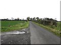
Upper Rickamore Road
Heading north-west
Image: © Kenneth Allen
Taken: 26 Oct 2009
0.21 miles
2
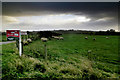
Stormy Weather
Sheep seek what shelter they can beside a hedge as a heavy autumn shower approaches. On the Rickamore Road Upper near Templepatrick
Image: © Robert Ashby
Taken: 14 Nov 2013
0.24 miles