IMAGES TAKEN NEAR TO
Grange Road, BALLYCLARE, BT39 0DJ
Introduction
This page details the photographs taken nearby to Grange Road, BT39 0DJ by members of the Geograph project.
The Geograph project started in 2005 with the aim of publishing, organising and preserving representative images for every square kilometre of Great Britain, Ireland and the Isle of Man.

There are currently over 7.5m images from over14,400 individuals and you can help contribute to the project by visiting https://www.geograph.org.uk
Image Map
Images are licensed for reuse under creativecommons.org/licenses/by-sa/2.0
Notes
- Clicking on the map will re-center to the selected point.
- The higher the marker number, the further away the image location is from the centre of the postcode.
Image Listing (4 Images Found)
Images are licensed for reuse under creativecommons.org/licenses/by-sa/2.0
Image
Details
Distance
1
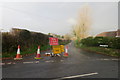
Road closed
Roadworks on the Hollybank Road caused traffic diversions along the Grange Road, normally a fairly quiet road.
Image: © Robert Ashby
Taken: 20 Nov 2014
0.14 miles
2
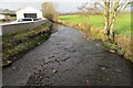
The Four Mile Burn
Photo taken from Grange Road looking northwest.
Image: © Robert Ashby
Taken: 20 Nov 2014
0.17 miles
4
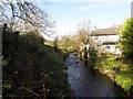
River at Fifty Acres
Looking north-west from the Hollybank Road
Image: © Kenneth Allen
Taken: 13 Nov 2009
0.18 miles