IMAGES TAKEN NEAR TO
Paradise Walk, BALLYCLARE, BT39 0DD
Introduction
This page details the photographs taken nearby to Paradise Walk, BT39 0DD by members of the Geograph project.
The Geograph project started in 2005 with the aim of publishing, organising and preserving representative images for every square kilometre of Great Britain, Ireland and the Isle of Man.

There are currently over 7.5m images from over14,400 individuals and you can help contribute to the project by visiting https://www.geograph.org.uk
Image Map
Images are licensed for reuse under creativecommons.org/licenses/by-sa/2.0
Notes
- Clicking on the map will re-center to the selected point.
- The higher the marker number, the further away the image location is from the centre of the postcode.
Image Listing (4 Images Found)
Images are licensed for reuse under creativecommons.org/licenses/by-sa/2.0
Image
Details
Distance
1
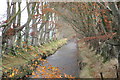
Ballymartin Water from the Loughanmore Road bridge
Looking more like a canal along this short stretch at Templepatrick, Ballymartin Water starts a few miles to the east at Hyde Park dam near Mallusk, eventually flowing in to the River Sixmilewater near Dunadry and on to Lough Neagh.
Image: © Robert Ashby
Taken: 20 Nov 2014
0.07 miles
2

Near Templepatrick
The Sixmilewater River from Paradise Walk with the Templepatrick Hilton Hotel in the background.
Image: © Robert Ashby
Taken: 21 Jul 2013
0.10 miles
3
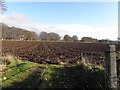
Countryside near Templepatrick
Looking ENE along Paradise Walk
Image: © Kenneth Allen
Taken: 17 Nov 2009
0.14 miles
4

Entrance, Hilton Hotgel, Templepatrick
It is located along Paradise Walk
Image: © Kenneth Allen
Taken: 17 Nov 2009
0.24 miles