IMAGES TAKEN NEAR TO
Castleton, BALLYCLARE, BT39 0AZ
Introduction
This page details the photographs taken nearby to Castleton, BT39 0AZ by members of the Geograph project.
The Geograph project started in 2005 with the aim of publishing, organising and preserving representative images for every square kilometre of Great Britain, Ireland and the Isle of Man.

There are currently over 7.5m images from over14,400 individuals and you can help contribute to the project by visiting https://www.geograph.org.uk
Image Map
Images are licensed for reuse under creativecommons.org/licenses/by-sa/2.0
Notes
- Clicking on the map will re-center to the selected point.
- The higher the marker number, the further away the image location is from the centre of the postcode.
Image Listing (17 Images Found)
Images are licensed for reuse under creativecommons.org/licenses/by-sa/2.0
Image
Details
Distance
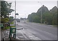
1
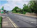
The Antrim Road, Templepatrick
The A6 Antrim Road on the outskirts of Templepatrick. A usually busy stretch as most traffic heading between Belfast and the International Airport at Aldergrove passes through here.
Image: © Rossographer
Taken: 19 May 2011
0.08 miles
2
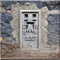
Flush Bracket, Templepatrick
Flush bracket bench mark on a wall surrounding Upton Park at the side of the A6 Antrim Road, Templepatrick.
The number on the bracket is OSBM 3267.
The mark has been levelled to 52.51 metres above MSL.
A flush bracket is a type of bench mark set onto the face of a building. See also http://www.geograph.org.uk/search.php?i=11037856 for many other examples I have found.
Image: © Rossographer
Taken: 19 May 2011
0.09 miles
3
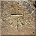
Bench Mark, Templepatrick
Cut bench mark on a wall surrounding Upton Park at the side of the A6 Antrim Road, Templepatrick.
The mark has been levelled to 53.50 metres above MSL.
See also http://www.geograph.org.uk/search.php?i=11037856 for many other examples I have found.
Image: © Rossographer
Taken: 19 May 2011
0.09 miles
4
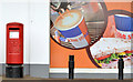
Pillar box BT39 689, Templepatrick
EIIR pillar box (BT39 689) at the Twelfth Milestone supermarket/petrol station and post office.
Image: © Albert Bridge
Taken: 3 May 2014
0.11 miles
5
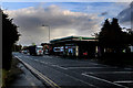
Templepatrick village
Service station and shopping centre in Templepatrick.
Image: © Robert Ashby
Taken: 14 Nov 2013
0.12 miles
6
Road scene at the north of Kilmakee
Photographer is standing near the roadway verge, but not on the road.
Image: © C Michael Hogan
Taken: 15 Jul 2011
0.15 miles
7
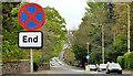
"End of clearway" sign, Templepatrick
An “end of clearway” sign on the Antrim Road – part of the busy main street and the road from Belfast to the International Airport at Aldergrove.
Image: © Albert Bridge
Taken: 3 May 2014
0.18 miles
8
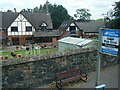
House seen from bus on Antrim Road, Templepatrick
Image: © Colin Pyle
Taken: 29 Jul 2022
0.18 miles
10
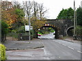
Bridge
This railway bridge carries the line from Belfast (to the left) to Londonderry.
Image: © Brian Shaw
Taken: 14 Nov 2005
0.21 miles