1
Pillar box BT39 689, Templepatrick
EIIR pillar box (BT39 689) at the Twelfth Milestone supermarket/petrol station and post office.
Image: © Albert Bridge
Taken: 3 May 2014
0.04 miles
2
Templepatrick village
Service station and shopping centre in Templepatrick.
Image: © Robert Ashby
Taken: 14 Nov 2013
0.04 miles
3
Road scene at the north of Kilmakee
Photographer is standing near the roadway verge, but not on the road.
Image: © C Michael Hogan
Taken: 15 Jul 2011
0.05 miles
4
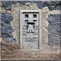
Flush Bracket, Templepatrick
Flush bracket bench mark on a wall surrounding Upton Park at the side of the A6 Antrim Road, Templepatrick.
The number on the bracket is OSBM 3267.
The mark has been levelled to 52.51 metres above MSL.
A flush bracket is a type of bench mark set onto the face of a building. See also http://www.geograph.org.uk/search.php?i=11037856 for many other examples I have found.
Image: © Rossographer
Taken: 19 May 2011
0.07 miles
5
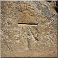
Bench Mark, Templepatrick
Cut bench mark on a wall surrounding Upton Park at the side of the A6 Antrim Road, Templepatrick.
The mark has been levelled to 53.50 metres above MSL.
See also http://www.geograph.org.uk/search.php?i=11037856 for many other examples I have found.
Image: © Rossographer
Taken: 19 May 2011
0.07 miles
6
The Antrim Road, Templepatrick
The A6 Antrim Road on the outskirts of Templepatrick. A usually busy stretch as most traffic heading between Belfast and the International Airport at Aldergrove passes through here.
Image: © Rossographer
Taken: 19 May 2011
0.07 miles
7
Accommodation crossing XL7, Kilmakee, Templepatrick
The manually-operated gates, at an accommodation crossing, a short distance on the Belfast side of Kilmakee level crossing
Image
Image: © Albert Bridge
Taken: 3 May 2014
0.14 miles
8
Airport bus, Templepatrick (May 2014)
An Ulsterbus Alexander (Falkirk) – bodied Volvo (2995 EEZ 2995) approaching the roundabout with the 11.00 Belfast Europa Buscentre - Belfast International (Aldergrove) Airport.
Image: © Albert Bridge
Taken: 3 May 2014
0.15 miles
9
The A57 Ballyrobin Road at Templepatrick
Leaving Templepatrick behind on the way to the airport.
Image: © Thomas Nugent
Taken: 1 Jun 2019
0.19 miles
10
The Antrim Road, Templepatrick (May 2014)
The Antrim/Dunadry exit from the roundabout on the Ballyrobin Road.
Image: © Albert Bridge
Taken: 3 May 2014
0.20 miles


