IMAGES TAKEN NEAR TO
Temple Rise, BALLYCLARE, BT39 0AG
Introduction
This page details the photographs taken nearby to Temple Rise, BT39 0AG by members of the Geograph project.
The Geograph project started in 2005 with the aim of publishing, organising and preserving representative images for every square kilometre of Great Britain, Ireland and the Isle of Man.

There are currently over 7.5m images from over14,400 individuals and you can help contribute to the project by visiting https://www.geograph.org.uk
Image Map
Images are licensed for reuse under creativecommons.org/licenses/by-sa/2.0
Notes
- Clicking on the map will re-center to the selected point.
- The higher the marker number, the further away the image location is from the centre of the postcode.
Image Listing (15 Images Found)
Images are licensed for reuse under creativecommons.org/licenses/by-sa/2.0
Image
Details
Distance
1
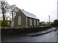
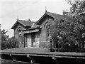
Old church, Templepatrick
Looking south-west
Image: © Kenneth Allen
Taken: 27 Oct 2014
0.18 miles
2
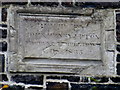
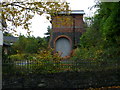
Plaque, Templepatrick
It includes the following text:
Built by John Henty Upton Viscount Templton AD 1835
Pictured here Image]
Image: © Kenneth Allen
Taken: 27 Oct 2014
0.18 miles
3
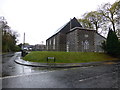
Old church, Templepatrick
Located at the corner of Lylehill Road and Coach Road
See close-up of plaque here Image]
Image: © Kenneth Allen
Taken: 27 Oct 2014
0.19 miles
4
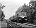
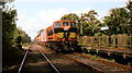
Antrim bound train at Templepatrick - 1980
The former LMS(NCC) main line from Bleach Green Junction to Antrim enjoyed a very chequered history in the final years of the 20th Century. "Mothballed" by Northern Ireland Railways when Derry line service transferred to Antrim - Lisburn from 23 January 1978, it reopened for passenger traffic on 16 June 1980, but numbers were poor and it closed again on 21 February 1981. However, the line reopened again in 2001.
A 2-car 80-class set pulls away from the staggered down platform at Templepatrick with the 14.10 passenger service from Belfast (York Road) to Antrim.
Image: © The Carlisle Kid
Taken: 5 Sep 1980
0.19 miles
5
Templepatrick railway station
Templepatrick railway station closed to passengers in 1965. It was unusual in that access to the main building was by way of a lift, which was still there - although very disused - when this photograph was taken. Reopened briefly in the early 1980s, this site is now private property.
Image: © The Carlisle Kid
Taken: 14 Jun 1975
0.21 miles
6
Old railway station, Templepatrick
Looking ENE from the village side
Turfburner got a good angle on it here Image]
Image: © Kenneth Allen
Taken: 27 Oct 2014
0.21 miles
7
Weed-spraying train,Templepatrick
The CIE weed-spraying train, hauled by 169S, approaching the closed station at Templepatrick Image The station had re-opened for a short experimental period in 1980 and still retained the blue and white name board.
Image: © Albert Bridge
Taken: 6 Jun 1985
0.21 miles
8
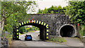
Railway bridge, Templepatrick (1)
The view outward, towards the Old Coach Road. Last seen from this side in Image (November 2005).
Image: © Albert Bridge
Taken: 24 Jun 2012
0.21 miles
9
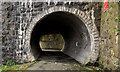
Railway bridge, Templepatrick (2)
The pedestrian tunnel looking out towards The Old Coach Road.
Image: © Albert Bridge
Taken: 24 Jun 2012
0.21 miles
10
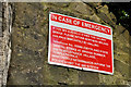
Railway bridge, Templepatrick (3)
The “bridge strike” sign on the inward side.
Image: © Albert Bridge
Taken: 24 Jun 2012
0.21 miles