IMAGES TAKEN NEAR TO
Plantation Drive, CARRICKFERGUS, BT38 9RF
Introduction
This page details the photographs taken nearby to Plantation Drive, BT38 9RF by members of the Geograph project.
The Geograph project started in 2005 with the aim of publishing, organising and preserving representative images for every square kilometre of Great Britain, Ireland and the Isle of Man.

There are currently over 7.5m images from over14,400 individuals and you can help contribute to the project by visiting https://www.geograph.org.uk
Image Map
Images are licensed for reuse under creativecommons.org/licenses/by-sa/2.0
Notes
- Clicking on the map will re-center to the selected point.
- The higher the marker number, the further away the image location is from the centre of the postcode.
Image Listing (3 Images Found)
Images are licensed for reuse under creativecommons.org/licenses/by-sa/2.0
Image
Details
Distance
1
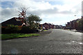
Craigs Road
At the junction with the B90 on the outskirts of Carrickfergus.
Image: © Robert Ashby
Taken: 26 Oct 2016
0.19 miles
2
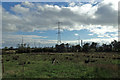
Source of power
Pylons taking power to the people from Kilroot power station. The chimney at Kilroot is just visible in the background.
Image: © Robert Ashby
Taken: 26 Oct 2016
0.21 miles
3
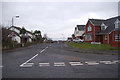
Kingsland Drive
This Street in Carrickfergus enjoys an excellent view right over to the far shore of Belfast Lough.
Image: © James Carroll
Taken: 12 Jan 2010
0.21 miles