IMAGES TAKEN NEAR TO
Balfour Avenue, CARRICKFERGUS, BT38 9RD
Introduction
This page details the photographs taken nearby to Balfour Avenue, BT38 9RD by members of the Geograph project.
The Geograph project started in 2005 with the aim of publishing, organising and preserving representative images for every square kilometre of Great Britain, Ireland and the Isle of Man.

There are currently over 7.5m images from over14,400 individuals and you can help contribute to the project by visiting https://www.geograph.org.uk
Image Map
Images are licensed for reuse under creativecommons.org/licenses/by-sa/2.0
Notes
- Clicking on the map will re-center to the selected point.
- The higher the marker number, the further away the image location is from the centre of the postcode.
Image Listing (181 Images Found)
Images are licensed for reuse under creativecommons.org/licenses/by-sa/2.0
Image
Details
Distance
1
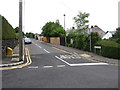
View northwest along Balfour Avenue, Whitehead
Image: © Eric Jones
Taken: 30 Jun 2017
0.04 miles
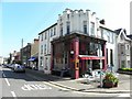
2
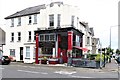
The Old Tea House Cafe and Delicatessen
This is located at the corner of Cable Road and King's Road.
Image: © Eric Jones
Taken: 30 Jun 2017
0.06 miles
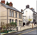
3
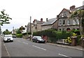
Victorian villas in Cable Road
Part of the Whitehead conservation area, these villas were built for commuting professionals after the Belfast to Larne railway line was constructed in the mid-19thC.
Image: © Eric Jones
Taken: 30 Jun 2017
0.06 miles
4
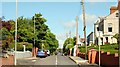
The Cable Road, Whitehead
Formerly called Queen’s Avenue, the Cable Road takes its name from the undersea telephone cable, from Portpatrick, established in 1893. It runs from beside the station Image to the Belfast Road.
Image: © Albert Bridge
Taken: 26 May 2009
0.06 miles
5
The Old Tea House, Whitehead
It is located at the corner of Cable Road and King's Road
Image: © Kenneth Allen
Taken: 28 Apr 2011
0.07 miles
6
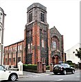
Whitehead Presbyterian Church
This is located in King's Road in the centre of the town.
Image: © Eric Jones
Taken: 30 Jun 2017
0.08 miles
7
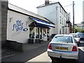
The Flower Shop, Whitehead
It is located along King's Road
Image: © Kenneth Allen
Taken: 28 Apr 2011
0.08 miles
8
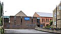
Vestry, parish hall, and car park at the rear the Whitehead Presbyterian Church
Image: © Eric Jones
Taken: 30 Jun 2017
0.08 miles
9
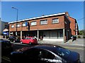
Former police station, Whitehead
The former part-time police station, at Balmoral Avenue, closed some time ago. It remains vacant and is offered for sale. Described as “Holding a prime site in the centre of Whitehead . . . . ex-Police Station and refurbished three bedroom dwelling house. Sitting on a site of approx. 3000 sq. ft and benefiting from a large enclosed car parking area to the rear the property”. This photograph appears as a matter of record only. I have no connection with any of the parties involved in the sale.
Image: © Albert Bridge
Taken: 4 Feb 2012
0.09 miles
10
Cadwell's Chemist, Whitehead
It is located along King's Road
Image: © Kenneth Allen
Taken: 28 Apr 2011
0.09 miles