IMAGES TAKEN NEAR TO
Raphael Road, CARRICKFERGUS, BT38 9QZ
Introduction
This page details the photographs taken nearby to Raphael Road, BT38 9QZ by members of the Geograph project.
The Geograph project started in 2005 with the aim of publishing, organising and preserving representative images for every square kilometre of Great Britain, Ireland and the Isle of Man.

There are currently over 7.5m images from over14,400 individuals and you can help contribute to the project by visiting https://www.geograph.org.uk
Image Map
Images are licensed for reuse under creativecommons.org/licenses/by-sa/2.0
Notes
- Clicking on the map will re-center to the selected point.
- The higher the marker number, the further away the image location is from the centre of the postcode.
Image Listing (82 Images Found)
Images are licensed for reuse under creativecommons.org/licenses/by-sa/2.0
Image
Details
Distance
1
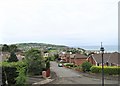
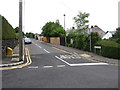
Raphael Road, Whitehead
The image of this suburban road was taken from the Belfast Road (A2).
Image: © Eric Jones
Taken: 30 Jun 2017
0.04 miles
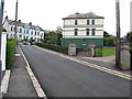
2
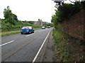
View North-westwards along the A2 (Belfast Road)
Image: © Eric Jones
Taken: 30 Jun 2017
0.06 miles
3
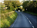
Belfast Road near Whitehead
Whitehead is a seaside village on the eastern coast of Northern Ireland, lying 20 miles from Belfast and roughly half way between the towns of Carrickfergus and Larne.
Image: © David Dixon
Taken: 29 Sep 2017
0.08 miles
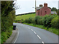
5
View northwest along Balfour Avenue, Whitehead
Image: © Eric Jones
Taken: 30 Jun 2017
0.10 miles
6
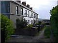
Greenfield Terrace, Whitehead
Short terrace on the edge of Whitehead, accessed from a lane from the A2 or Princess Park. There was formerly a flush bracket bench mark (OSBM 3397) on the side of the house nearest the camera but this has been destroyed.
Image: © Rossographer
Taken: 18 Jun 2011
0.11 miles
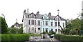
7
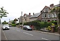
Victorian villas in Cable Road
Part of the Whitehead conservation area, these villas were built for commuting professionals after the Belfast to Larne railway line was constructed in the mid-19thC.
Image: © Eric Jones
Taken: 30 Jun 2017
0.11 miles
8
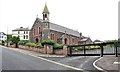
Our Lady of Lourdes Catholic Church, Whitehead
This church is served from Carrickfergus. A Catholic Primary School - Lourdes Primary School - and a parish hall are located at the rear of the chapel.
Image: © Eric Jones
Taken: 30 Jun 2017
0.11 miles
9
Large, imposing villa next to Our Lady of Lourdes Church
This house is at the junction of Victoria Avenue and the Prince of Wales Avenue.
Image: © Eric Jones
Taken: 30 Jun 2017
0.12 miles
10
Terraced Victorian villas in the Prince of Wales Avenue
These imposing houses are located high on the hillside and overlook the town and Belfast Lough.
Image: © Eric Jones
Taken: 30 Jun 2017
0.13 miles