IMAGES TAKEN NEAR TO
McCraes Brae, CARRICKFERGUS, BT38 9NZ
Introduction
This page details the photographs taken nearby to McCraes Brae, BT38 9NZ by members of the Geograph project.
The Geograph project started in 2005 with the aim of publishing, organising and preserving representative images for every square kilometre of Great Britain, Ireland and the Isle of Man.

There are currently over 7.5m images from over14,400 individuals and you can help contribute to the project by visiting https://www.geograph.org.uk
Image Map
Images are licensed for reuse under creativecommons.org/licenses/by-sa/2.0
Notes
- Clicking on the map will re-center to the selected point.
- The higher the marker number, the further away the image location is from the centre of the postcode.
Image Listing (48 Images Found)
Images are licensed for reuse under creativecommons.org/licenses/by-sa/2.0
Image
Details
Distance
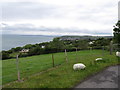
1
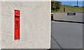
Wall box, Whitehead
GR wall box (BT38 154), near the Blackhead lighthouse, at McCrea’s Brae.
Image: © Albert Bridge
Taken: 27 Apr 2013
0.01 miles
3
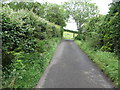
Approaching a sharp bend in the Blackhead Lighthouse Road
This, one of many sharp bends, is located above the clachan.
Image: © Eric Jones
Taken: 30 Jun 2017
0.03 miles
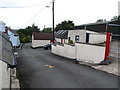
4
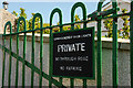
Irish Lights sign near Whitehead
The sign, on the gate at the start of the path to the Blackhead lighthouse, at the end of McCrea’s Brae. Although strictly speaking private and the property of The Lights the path is used by the public.
Image: © Albert Bridge
Taken: 3 May 2010
0.04 miles
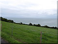
7
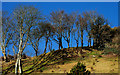
Trees near Whitehead
Overlooking the Blackhead path. Belfast Lough is behind me.
Image: © Albert Bridge
Taken: 9 Mar 2010
0.11 miles
8
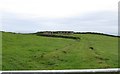
Surviving buildings of the Blackhead Chain Home Station
A roadway and two concrete buildings have survived. The ruins of other buildings and structures lie close by.
Image: © Eric Jones
Taken: 30 Jun 2017
0.11 miles
9
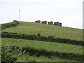
Chain Home Low Radio Station at Blackhead
The "Chain Home Low" was a WWII radar system providing early warning of the approach of enemy aircraft. These structures on a hill top above the main buildings were concrete stands for the detection equipment.
Image: © Eric Jones
Taken: 30 Jun 2017
0.11 miles
10
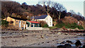
Former holiday bungalows, Whitehead
During the early part of the 20th century east Antrim, roughly from Eden to Islandmagee, was a popular spot for wooden holiday bungalows. These two (then vacant and boarded-up and subsequently removed) were beside the Blackhead path (“Old Castle Road” on the Google map) to the lighthouse. For another example (also removed) see Image (July 2009).
Image: © Albert Bridge
Taken: 22 Jan 1983
0.16 miles