IMAGES TAKEN NEAR TO
Bellahill Road, CARRICKFERGUS, BT38 9LE
Introduction
This page details the photographs taken nearby to Bellahill Road, BT38 9LE by members of the Geograph project.
The Geograph project started in 2005 with the aim of publishing, organising and preserving representative images for every square kilometre of Great Britain, Ireland and the Isle of Man.

There are currently over 7.5m images from over14,400 individuals and you can help contribute to the project by visiting https://www.geograph.org.uk
Image Map
Images are licensed for reuse under creativecommons.org/licenses/by-sa/2.0
Notes
- Clicking on the map will re-center to the selected point.
- The higher the marker number, the further away the image location is from the centre of the postcode.
Image Listing (4 Images Found)
Images are licensed for reuse under creativecommons.org/licenses/by-sa/2.0
Image
Details
Distance
3
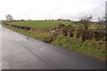
Bellahill Road near Carrickfergus
This little stream crossing under the road is a good landmark for walkers. Drivers would probably not see it at all. Only a small bend of the river can be seen in this picture.
Image: © James Carroll
Taken: 16 Jan 2010
0.15 miles
4
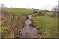
Bellahill Road near Carrickfergus
A clear view of one of several streams that crosses under the Bellahill Road. I find it noteworthy that this road curves round Ballyhill and heads for Ballagh Hill and is not apparently named for either. It may be an alternative spelling of the latter.
Image: © James Carroll
Taken: 16 Jan 2010
0.15 miles