IMAGES TAKEN NEAR TO
Beltoy Road, CARRICKFERGUS, BT38 9LB
Introduction
This page details the photographs taken nearby to Beltoy Road, BT38 9LB by members of the Geograph project.
The Geograph project started in 2005 with the aim of publishing, organising and preserving representative images for every square kilometre of Great Britain, Ireland and the Isle of Man.

There are currently over 7.5m images from over14,400 individuals and you can help contribute to the project by visiting https://www.geograph.org.uk
Image Map
Images are licensed for reuse under creativecommons.org/licenses/by-sa/2.0
Notes
- Clicking on the map will re-center to the selected point.
- The higher the marker number, the further away the image location is from the centre of the postcode.
Image Listing (2 Images Found)
Images are licensed for reuse under creativecommons.org/licenses/by-sa/2.0
Image
Details
Distance
1
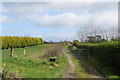
No Entry
A gate beside the Beltoy Road bars the way to the overgrown path leading to who knows where.
Image: © Robert Ashby
Taken: 13 Apr 2014
0.03 miles
2
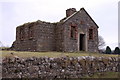
Former national school near Carrickfergus
A former national school on the Beltoy Road - slightly surprising that it has survived as a ruin and not been converted to or replaced by a house. There is a plaque above the door but the name of the school has been defaced. A visitor to the site has commented "The name of this school is Bellahill National Male School - there was a similar one for females located about 3 miles nearer Carrickfergus but no ruins remain of it (that I am aware of anyway)" and given the date of construction as 1858.
Image: © Albert Bridge
Taken: 22 Dec 2006
0.13 miles