IMAGES TAKEN NEAR TO
Mill Lane, CARRICKFERGUS, BT38 9JW
Introduction
This page details the photographs taken nearby to Mill Lane, BT38 9JW by members of the Geograph project.
The Geograph project started in 2005 with the aim of publishing, organising and preserving representative images for every square kilometre of Great Britain, Ireland and the Isle of Man.

There are currently over 7.5m images from over14,400 individuals and you can help contribute to the project by visiting https://www.geograph.org.uk
Image Map
Images are licensed for reuse under creativecommons.org/licenses/by-sa/2.0
Notes
- Clicking on the map will re-center to the selected point.
- The higher the marker number, the further away the image location is from the centre of the postcode.
Image Listing (2 Images Found)
Images are licensed for reuse under creativecommons.org/licenses/by-sa/2.0
Image
Details
Distance
1
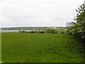
Aldfreck Townand
Looking east in the direction of Larne Lough
Image: © Kenneth Allen
Taken: 1 Jun 2010
0.22 miles
2
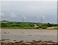
Powerlines crossing Oldchurch Bay
These power lines run south-eastwards from the Ballylumford natural gas powered station which generated half of all Northern Ireland's electricity. They cross Larne Lough at Tommy Hill's Point. Other power lines cross further north at Barney's Point.
Image: © Eric Jones
Taken: 26 Sep 2013
0.25 miles