IMAGES TAKEN NEAR TO
Forthill Road, CARRICKFERGUS, BT38 9JU
Introduction
This page details the photographs taken nearby to Forthill Road, BT38 9JU by members of the Geograph project.
The Geograph project started in 2005 with the aim of publishing, organising and preserving representative images for every square kilometre of Great Britain, Ireland and the Isle of Man.

There are currently over 7.5m images from over14,400 individuals and you can help contribute to the project by visiting https://www.geograph.org.uk
Image Map
Images are licensed for reuse under creativecommons.org/licenses/by-sa/2.0
Notes
- Clicking on the map will re-center to the selected point.
- The higher the marker number, the further away the image location is from the centre of the postcode.
Image Listing (3 Images Found)
Images are licensed for reuse under creativecommons.org/licenses/by-sa/2.0
Image
Details
Distance
1
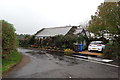
Near Ballycarry
An attractive little flower-bedecked cottage at the junction of Forthill Road and Main Bentra Road. The effect is somewhat spoiled by the wheely bins. Rain stopped play at this point as the wind was blowing it into my camera lens.
Image: © Robert Ashby
Taken: 26 Oct 2016
0.14 miles
2
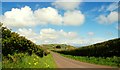
The Main Bentra Road near Whitehead
The Main Bentra Road runs from the Rawbrae Road near Whitehead towards Ballycarry. This is the view towards the latter.
Image: © Albert Bridge
Taken: 29 Apr 2008
0.20 miles
3
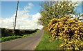
The Acreback Road near Whitehead
See Image The Acreback Road runs off the Main Bentra Road to the Rawbrae Road Image The view is towards the former.
Image: © Albert Bridge
Taken: 29 Apr 2008
0.25 miles