IMAGES TAKEN NEAR TO
Woodlands, CARRICKFERGUS, BT38 9JD
Introduction
This page details the photographs taken nearby to Woodlands, BT38 9JD by members of the Geograph project.
The Geograph project started in 2005 with the aim of publishing, organising and preserving representative images for every square kilometre of Great Britain, Ireland and the Isle of Man.

There are currently over 7.5m images from over14,400 individuals and you can help contribute to the project by visiting https://www.geograph.org.uk
Image Map
Images are licensed for reuse under creativecommons.org/licenses/by-sa/2.0
Notes
- Clicking on the map will re-center to the selected point.
- The higher the marker number, the further away the image location is from the centre of the postcode.
Image Listing (5 Images Found)
Images are licensed for reuse under creativecommons.org/licenses/by-sa/2.0
Image
Details
Distance
1
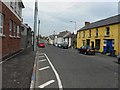
Main Street, Ballycarry
Looking north
Image: © Kenneth Allen
Taken: 24 Apr 2010
0.11 miles
2
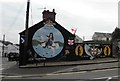
Mural, Ballycarry
It is located at the centre of the village on West Street, adjacent to Main Street
Image: © Kenneth Allen
Taken: 24 Apr 2010
0.15 miles
4
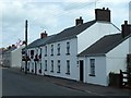
Main Street, Ballycarry
Attractive terrace of white painted houses in Main Street, Ballycarry.
Image: © Robert Ashby
Taken: 17 Jul 2013
0.24 miles
5
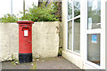
Pillar box, Ballycarry
EIIR pillar box (BT38 85) at Ballycarry post office, Main Street.
Image: © Albert Bridge
Taken: 30 Jun 2013
0.24 miles