IMAGES TAKEN NEAR TO
Island Road Lower, CARRICKFERGUS, BT38 9HB
Introduction
This page details the photographs taken nearby to Island Road Lower, BT38 9HB by members of the Geograph project.
The Geograph project started in 2005 with the aim of publishing, organising and preserving representative images for every square kilometre of Great Britain, Ireland and the Isle of Man.

There are currently over 7.5m images from over14,400 individuals and you can help contribute to the project by visiting https://www.geograph.org.uk
Image Map
Images are licensed for reuse under creativecommons.org/licenses/by-sa/2.0
Notes
- Clicking on the map will re-center to the selected point.
- The higher the marker number, the further away the image location is from the centre of the postcode.
Image Listing (29 Images Found)
Images are licensed for reuse under creativecommons.org/licenses/by-sa/2.0
Image
Details
Distance
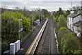
1
Ballycarry Station
Ballycarry Station looking towards Larne
Image: © Wilson Adams
Taken: 3 Jan 2007
0.06 miles
2
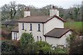
Ballycarry Station
Ballycarry Station, now privately owned
Image: © Wilson Adams
Taken: 3 Jan 2007
0.07 miles
3
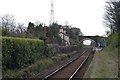
Railway bridge, Ballycarry station - August 2018(3)
Traffic lights on the Ballycarry side.
Image: © Albert Bridge
Taken: 2 Aug 2018
0.10 miles
4
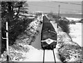
Train and snow - Ballycarry
Just to show that snow in March does happen. One of Northern Ireland Railways 70-class DEMUs approaches Ballycarry station with the 10.45 passenger service from Larne Harbour to Belfast (York Road). Built by the Ulster Transport Authority 1966-68, the 70-class were withdrawn 1979-86, with this unit (73) being disposed of in August 1985.
Image: © The Carlisle Kid
Taken: 21 Mar 1980
0.10 miles
5
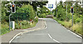
Ballycarry station, 2009 (4)
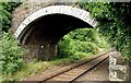
See Image This single-arch ivy-clad bridge carries the Island Road Lower/Lough Road across the line at the Larne Harbour end of the station. Continue to Image
Image: © Albert Bridge
Taken: 28 Jul 2009
0.11 miles
6
Ballycarry station, 2009 (3)
Image: © Albert Bridge
Taken: 28 Jul 2009
0.11 miles
7
Railway bridge, Ballycarry station - August 2018(1)
The bridge from the Islandmagee side. The raised walls make it very difficult to take photographs such as Image (March 1980) and Image (June 1985).
Image: © Albert Bridge
Taken: 2 Aug 2018
0.11 miles
8
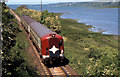
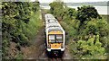
Train, Ballycarry (1985)
See Image (June 2012). A similar view in 1985 of the 13.30 Belfast – York Road – Larne Harbour (87,778,752) immediately after departing Ballycarry. Larne Lough is on the right. There has been a considerable growth in lineside vegetation in the intervening 27 years.
Image: © Albert Bridge
Taken: 6 Jun 1985
0.11 miles
9
Train, Ballycarry (2012-2)
See Image The same train departing Ballycarry station, along the shore of Larne Lough, for Larne Harbour. Image shows a similar view in 1985.
Image: © Albert Bridge
Taken: 5 Jun 2012
0.11 miles
10
Ballycarry Railway Station
The quiet station at Ballycarry between Whitehead and Larne. In 1977 it looked like this Image
Image: © Rossographer
Taken: 18 Feb 2023
0.12 miles