IMAGES TAKEN NEAR TO
Copeland View, CARRICKFERGUS, BT38 9DQ
Introduction
This page details the photographs taken nearby to Copeland View, BT38 9DQ by members of the Geograph project.
The Geograph project started in 2005 with the aim of publishing, organising and preserving representative images for every square kilometre of Great Britain, Ireland and the Isle of Man.

There are currently over 7.5m images from over14,400 individuals and you can help contribute to the project by visiting https://www.geograph.org.uk
Image Map
Images are licensed for reuse under creativecommons.org/licenses/by-sa/2.0
Notes
- Clicking on the map will re-center to the selected point.
- The higher the marker number, the further away the image location is from the centre of the postcode.
Image Listing (2 Images Found)
Images are licensed for reuse under creativecommons.org/licenses/by-sa/2.0
Image
Details
Distance
1
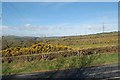
Power lines
Looking W from the Red Brae Road. Shows the two sets of power lines marked on OS maps. Grid ref is the pylon in the left third of scene where the line turns SW.
Image: © James Carroll
Taken: 7 Apr 2008
0.18 miles
2
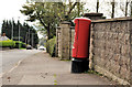
Pillar box, Carrickfergus
A leaning EIIR pillar box, on the North Road, near the corner of the Middle Road.
Image: © Albert Bridge
Taken: 14 Oct 2011
0.21 miles