IMAGES TAKEN NEAR TO
Dalways Bawn Road, CARRICKFERGUS, BT38 9BY
Introduction
This page details the photographs taken nearby to Dalways Bawn Road, BT38 9BY by members of the Geograph project.
The Geograph project started in 2005 with the aim of publishing, organising and preserving representative images for every square kilometre of Great Britain, Ireland and the Isle of Man.

There are currently over 7.5m images from over14,400 individuals and you can help contribute to the project by visiting https://www.geograph.org.uk
Image Map
Images are licensed for reuse under creativecommons.org/licenses/by-sa/2.0
Notes
- Clicking on the map will re-center to the selected point.
- The higher the marker number, the further away the image location is from the centre of the postcode.
Image Listing (4 Images Found)
Images are licensed for reuse under creativecommons.org/licenses/by-sa/2.0
Image
Details
Distance
1

Dalway's Bawn
A Bawn is a name used for a cow fortress, presumably to keep livestock safe from marauding cattle thieves. This one dates back to c 1606. Located on the Dalway's Bawn Road on the way to Ballycarry.
Image: © Robert Ashby
Taken: 26 Oct 2016
0.03 miles
2
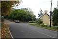
Dalway's Bawn Road
A tricky sharp bend on the way to Ballycarry.
Image: © Robert Ashby
Taken: 26 Oct 2016
0.20 miles
3
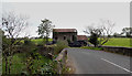
Near Ballycarry
The remains of what looks like an old mill with bags of silage stored round it. Located at Bridge End.
Image: © Robert Ashby
Taken: 26 Oct 2016
0.24 miles
4
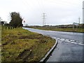
Dalway's Bawn Road, Kilroot
This part of the main road from Carrickfergus and Belfast to the expanding village of Ballycarry. It is met here by the Tongue Loanen - which brings traffic from the main A2 at Kilroot.
Dalway's Bawn refer to the ruined fort that Scottish planter John Dalway built himself in 1609.
Townland of Ballyhill.
Image: © Dean Molyneaux
Taken: 28 Feb 2010
0.24 miles