IMAGES TAKEN NEAR TO
Fort Road, CARRICKFERGUS, BT38 9BS
Introduction
This page details the photographs taken nearby to Fort Road, BT38 9BS by members of the Geograph project.
The Geograph project started in 2005 with the aim of publishing, organising and preserving representative images for every square kilometre of Great Britain, Ireland and the Isle of Man.

There are currently over 7.5m images from over14,400 individuals and you can help contribute to the project by visiting https://www.geograph.org.uk
Image Map
Images are licensed for reuse under creativecommons.org/licenses/by-sa/2.0
Notes
- Clicking on the map will re-center to the selected point.
- The higher the marker number, the further away the image location is from the centre of the postcode.
Image Listing (4 Images Found)
Images are licensed for reuse under creativecommons.org/licenses/by-sa/2.0
Image
Details
Distance
1
Old church and graveyard, Kilroot (3)
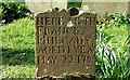
See Image This one marks the grave of Francis Mulcahy who died, at the age of one, in 1758.
Image: © Albert Bridge
Taken: 22 Mar 2008
0.20 miles
2
Old church and graveyard, Kilroot (2)
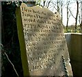
See Image This headstone (which no longer marks a grave) records several deaths. The first was James Davey in 1777.
Image: © Albert Bridge
Taken: 22 Mar 2008
0.21 miles
3
Old church and graveyard, Kilroot (1)
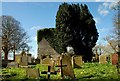
It is believed that there was a church on this site in the time before St Patrick. The present ruin is said to be “medieval” without any date given. There is also supposed to have been an earlier graveyard but the present one seems to date from the 18th century. Jonathan Swift Image was Dean but the church is thought to have been in ruins even then.
Image: © Albert Bridge
Taken: 22 Mar 2008
0.21 miles
4
Old church and graveyard, Kilroot (4)
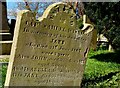
See Image This Victorian headstone marks the grave of several members of the Wisnom family. The first death is that of Capt Samuel Wisnom in 1865.
Image: © Albert Bridge
Taken: 22 Mar 2008
0.22 miles