IMAGES TAKEN NEAR TO
Farm Lodge Drive, CARRICKFERGUS, BT38 8XN
Introduction
This page details the photographs taken nearby to Farm Lodge Drive, BT38 8XN by members of the Geograph project.
The Geograph project started in 2005 with the aim of publishing, organising and preserving representative images for every square kilometre of Great Britain, Ireland and the Isle of Man.

There are currently over 7.5m images from over14,400 individuals and you can help contribute to the project by visiting https://www.geograph.org.uk
Image Map
Images are licensed for reuse under creativecommons.org/licenses/by-sa/2.0
Notes
- Clicking on the map will re-center to the selected point.
- The higher the marker number, the further away the image location is from the centre of the postcode.
Image Listing (4 Images Found)
Images are licensed for reuse under creativecommons.org/licenses/by-sa/2.0
Image
Details
Distance
1
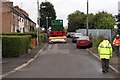
Upper Station Road, Greenisland
Low loader and steam engine reversing down Loughview Terrace, Upper Station Road, Greenisland.
Image: © Wilson Adams
Taken: 4 Aug 2005
0.07 miles
2
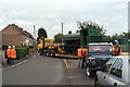
Upper Station Road, Greenisland
Upper Station Road, Greenisland
Image: © Wilson Adams
Taken: 4 Aug 2005
0.07 miles
3
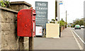
Postbox BT38 305, Greenisland
Post-mounted EIIR box (“Knockagh”) BT38 305 on the Upper Road.
Image: © Albert Bridge
Taken: 9 Apr 2014
0.22 miles
4
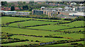
Railway and fields near Greenisland
There are still some undeveloped green fields between Belfast and Carrickfergus (but not many). Those in the photo are between Jordanstown and Greenisland. The Belfast – Larne Harbour railway is at the bottom and the University of Ulster’s Jordanstown campus Image at top right. The view is from the war memorial at Knockagh Image
Image: © Albert Bridge
Taken: 6 May 2010
0.24 miles