IMAGES TAKEN NEAR TO
Glassillan Grove, CARRICKFERGUS, BT38 8TB
Introduction
This page details the photographs taken nearby to Glassillan Grove, BT38 8TB by members of the Geograph project.
The Geograph project started in 2005 with the aim of publishing, organising and preserving representative images for every square kilometre of Great Britain, Ireland and the Isle of Man.

There are currently over 7.5m images from over14,400 individuals and you can help contribute to the project by visiting https://www.geograph.org.uk
Image Map
Images are licensed for reuse under creativecommons.org/licenses/by-sa/2.0
Notes
- Clicking on the map will re-center to the selected point.
- The higher the marker number, the further away the image location is from the centre of the postcode.
Image Listing (14 Images Found)
Images are licensed for reuse under creativecommons.org/licenses/by-sa/2.0
Image
Details
Distance
1
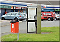
Telephone box, Greenisland (May 2015)
A KX300 telephone box, at Glassillan Court, in the Greenisland estate.
Image: © Albert Bridge
Taken: 16 May 2015
0.02 miles
2
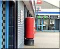
Pillar box, Greenisland (May 2015)
EIIR pillar box (BT38 604), at Glassillan Court, in the Greenisland estate.
Image: © Albert Bridge
Taken: 16 May 2015
0.04 miles
3
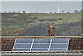
Solar panels, Greenisland (April 2016)
Solar panels on a house in the Greenisland estate. Once rare, they are (slowly) becoming more common around the greater Belfast area. Image is in the background.
Image: © Albert Bridge
Taken: 18 Apr 2016
0.07 miles
4
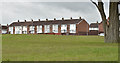
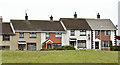
Knockleigh Drive, Greenisland (April 2016)
Knockleigh Drive – houses on the north western side of a large green space in the Greenisland estate. Such spaces were once a feature of social housing.
Image: © Albert Bridge
Taken: 18 Apr 2016
0.09 miles
5
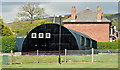
Community Council building, Greenisland (May 2015)
A metal building, at 84 Station Road, which the organisation’s website confirms is an ex-army structure acquired in 1978. The former Carrickfergus Borough Council had plans for a new community centre which, if they come to fruition under the new council, might mean that this building’s future is uncertain.
Image: © Albert Bridge
Taken: 16 May 2015
0.10 miles
6
Knockleigh Walk, Greenisland (April 2016)
Knockleigh Walk – houses on the south western side of a large green space in the Greenisland estate. Such spaces were once a feature of social housing.
Image: © Albert Bridge
Taken: 18 Apr 2016
0.15 miles
7
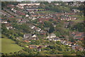
Greenisland seen from Knockagh
Greenisland, although part of the borough of Carrickfergus, is very much part of greater Belfast. This is Greenisland as seen from the war memorial at Knockagh. The Station Road runs from top left to bottom right.
Image: © Albert Bridge
Taken: 28 May 2006
0.17 miles
8
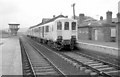
Greenisland Station (1980)
An NIR 80 Class railcar set #98/751, waiting for passengers to board at Greenisland Station, before continuing on its journey to Carrickfergus.
Image: © Wilson Adams
Taken: 4 Apr 1980
0.17 miles
10
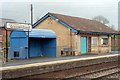
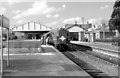
Greenisland Station (2005)
Greenisland Station and modern passenger waiting shelter on the Down platform to Larne.
Image: © Wilson Adams
Taken: 9 Dec 2005
0.17 miles