IMAGES TAKEN NEAR TO
Woodburn Road, CARRICKFERGUS, BT38 8PS
Introduction
This page details the photographs taken nearby to Woodburn Road, BT38 8PS by members of the Geograph project.
The Geograph project started in 2005 with the aim of publishing, organising and preserving representative images for every square kilometre of Great Britain, Ireland and the Isle of Man.

There are currently over 7.5m images from over14,400 individuals and you can help contribute to the project by visiting https://www.geograph.org.uk
Image Map
Images are licensed for reuse under creativecommons.org/licenses/by-sa/2.0
Notes
- Clicking on the map will re-center to the selected point.
- The higher the marker number, the further away the image location is from the centre of the postcode.
Image Listing (9 Images Found)
Images are licensed for reuse under creativecommons.org/licenses/by-sa/2.0
Image
Details
Distance
1
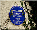
Crichton VC plaque, Carrickfergus
A plaque, visible from the Woodburn Road, commemorating James Bell Crichton who was awarded the Victoria Cross while serving in the New Zealand army during WW1 http://www.ulsterhistory.co.uk/crichtonVC.htm. The house no longer exists – the area is now in commercial use. Taken from outside the gate with considerable help from “Bertha”.
Image: © Albert Bridge
Taken: 5 Feb 2011
0.05 miles
2
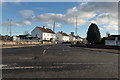
Outskirts of Carrickfergus
Woodburn Road leading to Carrickfergus.
Image: © Robert Ashby
Taken: 23 Nov 2016
0.18 miles
3
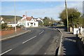
Woodburn crossroads
Crossing of Middle Road (B90) and Woodburn Road, Carrickfergus. Looking NW from Woodburn Road.
Image: © James Carroll
Taken: 7 Apr 2008
0.20 miles
4
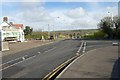
Woodburn crossroads
Crossing of Middle Road (B90) and Woodburn Road, Carrickfergus. Looking N along B90
Image: © James Carroll
Taken: 7 Apr 2008
0.20 miles
5
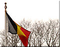
The Henly Gate, Carrickfergus (4)
The Belgian flag flying on the gate.
Image: © Albert Bridge
Taken: 5 Feb 2011
0.23 miles
6
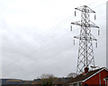
Pylons and power lines, Carrickfergus (2)
A pylon, on the other side of the Woodburn Road (at Woodlawn Avenue) from Image The lines continue towards Glengormley – no further shots of this line so far.
Image: © Albert Bridge
Taken: 5 Feb 2011
0.23 miles
7
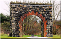
The Henly Gate, Carrickfergus (1)
The gate as it stands today, among modern housing, with the memorial and commemorative plaque at the bottom.
Image: © Albert Bridge
Taken: 5 Feb 2011
0.24 miles
8
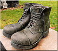
The Henly Gate, Carrickfergus (2)
The memorial – in the form of a pair of army boots.
Image: © Albert Bridge
Taken: 5 Feb 2011
0.24 miles
9
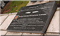
The Henly Gate, Carrickfergus (3)
The commemorative plaque – at an unusual angle to avoid reflections.
Image: © Albert Bridge
Taken: 5 Feb 2011
0.24 miles