IMAGES TAKEN NEAR TO
Shaftesbury Drive, CARRICKFERGUS, BT38 8LL
Introduction
This page details the photographs taken nearby to Shaftesbury Drive, BT38 8LL by members of the Geograph project.
The Geograph project started in 2005 with the aim of publishing, organising and preserving representative images for every square kilometre of Great Britain, Ireland and the Isle of Man.

There are currently over 7.5m images from over14,400 individuals and you can help contribute to the project by visiting https://www.geograph.org.uk
Image Map
Images are licensed for reuse under creativecommons.org/licenses/by-sa/2.0
Notes
- Clicking on the map will re-center to the selected point.
- The higher the marker number, the further away the image location is from the centre of the postcode.
Image Listing (328 Images Found)
Images are licensed for reuse under creativecommons.org/licenses/by-sa/2.0
Image
Details
Distance
1
Former railway path, Carrickfergus
There was a path running, between the railway and Shaftesbury Park, from St Bride’s Street towards Barn station. It seemed to fall into disuse over a number of years as it became overgrown. The fence now blocks access to it.
Image: © Albert Bridge
Taken: 19 Sep 2009
0.03 miles
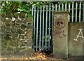
2
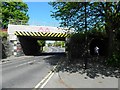
Railway bridge, Carrickfergus (2)
See Image There was (and still is) very limited space under the bridge in the previous photo for pedestrians passing on the eastern side. This subway was built (late 70’s if my memory is correct) to correct that deficiency. Continue to Image
Image: © Albert Bridge
Taken: 19 Sep 2009
0.03 miles
3
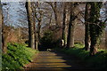
Lane off the North Road, Carrickfergus
The lane leading from the North Road to the cemetery.
Image: © Albert Bridge
Taken: 30 Jan 2007
0.03 miles
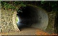
4
Railway bridge, Carrickfergus (1)
The bridge carries the Belfast (left) – Larne Harbour line across St Bride’s Street/the North Road. See also Image Image (July 2013) shows the bridge after rebuilding.
Image: © Albert Bridge
Taken: 19 Sep 2009
0.04 miles
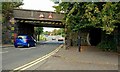
5
Low bridge, St Bride's Street
The road is heading north
Image: © Kenneth Allen
Taken: 28 Apr 2011
0.04 miles
6
Fergus Avenue, Carrickfergus (2)
See Image The North Road end of the same street.
Image: © Albert Bridge
Taken: 1 Apr 2010
0.04 miles
7
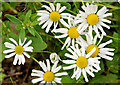
Oxeye daisies, Carrickfergus
Part of a considerable growth of oxeye daisies http://www.habitas.org.uk/flora/species.asp?item=4464 along the path, off the North Road, towards the old millponds.
Image: © Albert Bridge
Taken: 10 Jul 2013
0.04 miles
8
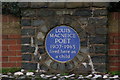
Louis Macneice plaque, Carrickfergus
The poet Louis Macneice lived in the North Road, Carrickfergus – his father was rector of St Nicholas's Church. The site is now occupied by sheltered housing. This plaque is at the entrance to the Macneice Fold. For more information see http://www.ulsterhistory.co.uk/louismcneice.htm. He was buried at Christ Church, Carrowdore Image See also Image (September 2013).
Image: © Albert Bridge
Taken: 30 Jan 2007
0.04 miles
9
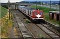
Barn railway station (2)
See Image The condition of the Belfast - Larne line had deteriorated considerably but it was to be almost another 20 years before the permanent way was entirely renewed. The track at the closed Barn station was not untypical of the line as a whole. It was only when I scanned this slide that I realised just how bad it had been. The station no longer exists Image The view is towards Belfast.
Image: © Albert Bridge
Taken: 3 Jul 1986
0.05 miles
10
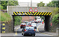
The North Road railway bridge, Carrickfergus (2013)
See Image (September 2009). For the record, the bridge (looking inward) as rebuilt. See also Image (April 2011).
Image: © Albert Bridge
Taken: 10 Jul 2013
0.05 miles