IMAGES TAKEN NEAR TO
Sunnylands Avenue, CARRICKFERGUS, BT38 8JJ
Introduction
This page details the photographs taken nearby to Sunnylands Avenue, BT38 8JJ by members of the Geograph project.
The Geograph project started in 2005 with the aim of publishing, organising and preserving representative images for every square kilometre of Great Britain, Ireland and the Isle of Man.

There are currently over 7.5m images from over14,400 individuals and you can help contribute to the project by visiting https://www.geograph.org.uk
Image Map
Images are licensed for reuse under creativecommons.org/licenses/by-sa/2.0
Notes
- Clicking on the map will re-center to the selected point.
- The higher the marker number, the further away the image location is from the centre of the postcode.
Image Listing (6 Images Found)
Images are licensed for reuse under creativecommons.org/licenses/by-sa/2.0
Image
Details
Distance
1
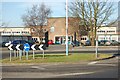
Sunnylands Primary School
Situated in Sunnylands Avenue. Picture taken from the end of Bridewell Drive, Carrickfergus. Grid Ref is GPs at main entrance.
Image: © James Carroll
Taken: 7 Apr 2008
0.01 miles
2
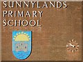
School logo
Sunnylands Primary School, Sunnylands Avenue, Carrickfergus
Image: © James Carroll
Taken: 7 Apr 2008
0.01 miles
3
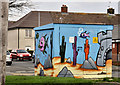
Electricity substation, Carrickfergus
A brightly-painted substation (marked “Shaftesbury Cross”) at Bridewell Drive, close to Image
Image: © Albert Bridge
Taken: 30 Nov 2011
0.09 miles
4
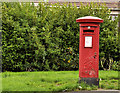
Pillar box, Carrickfergus
GVIR pillar box, at Sunnylands post office, Bridewell Drive.
Image: © Albert Bridge
Taken: 30 Nov 2011
0.11 miles
5
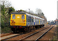
80-class railcars, Clipperstown
The 12.12 Belfast Central – Carrickfergus (background) departing Clipperstown. This stock is due for replacement next year.
Image: © Albert Bridge
Taken: 3 Mar 2010
0.23 miles
6
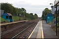
Clipperstown station, Carrickfergus
Clipperstown station opened in 1925 and was a basic halt with corrugated iron shelters (but not with the ascetic merit of a Great Western “pagoda”) and short platforms. The platforms are now longer and the shelters are the modern equivalent. There were sidings to a salt works and the branch to Carrickfergus harbour diverged on the Belfast side. This is the view to Larne Harbour.
Image: © Albert Bridge
Taken: 29 Sep 2006
0.25 miles