IMAGES TAKEN NEAR TO
Barton Park Gardens, BT38 8GD
Introduction
This page details the photographs taken nearby to Barton Park Gardens, BT38 8GD by members of the Geograph project.
The Geograph project started in 2005 with the aim of publishing, organising and preserving representative images for every square kilometre of Great Britain, Ireland and the Isle of Man.

There are currently over 7.5m images from over14,400 individuals and you can help contribute to the project by visiting https://www.geograph.org.uk
Image Map
Images are licensed for reuse under creativecommons.org/licenses/by-sa/2.0
Notes
- Clicking on the map will re-center to the selected point.
- The higher the marker number, the further away the image location is from the centre of the postcode.
Image Listing (89 Images Found)
Images are licensed for reuse under creativecommons.org/licenses/by-sa/2.0
Image
Details
Distance
1
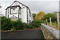
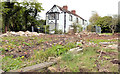
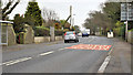
Shore Road
Derelict mock-tudor house. Victim of the A2 dual carriageway construction?
Image: © Robert Ashby
Taken: 28 Oct 2015
0.01 miles
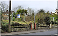
2
Vested house, Greenisland (2013-2)
A substantial detached house, facing the Shore Road, now vacant and awaiting demolition. The garden has already been cleared.
Image: © Albert Bridge
Taken: 4 May 2013
0.02 miles
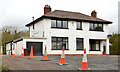
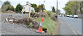
3
Vacant house, Jordanstown
A vacant house, on the Shore Road, with a substantial garden behind the hedge on the right, acquired in advance of road widening.
Image: © Albert Bridge
Taken: 31 Mar 2011
0.02 miles
4
Houses, Jordanstown/Greenisland (1)
One of several houses, along the present road, awaiting demolition. This one, on the Carrickfergus side of Silverstream Banks Image, was last seen in Image (March 2011).
Image: © Albert Bridge
Taken: 16 Feb 2012
0.03 miles
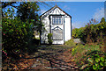
5
Vested house, Greenisland (2013-1)
This vacant house Image, set well back from the Shore Road, is still standing but the grounds have been cleared.
Image: © Albert Bridge
Taken: 4 May 2013
0.03 miles
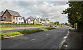
6
The Shore Road, Greenisland (2013-2)
The Shore Road, between Silverstream Banks and Neill’s Lane, looking towards Carrickfergus. The cleared area (left) was once the garden of this house Image
Image: © Albert Bridge
Taken: 4 May 2013
0.04 miles
7
The A2 Shore Road at Jordanstown
The A2 at Jordanstown looking towards Carrickfergus.
Image: © Rossographer
Taken: 27 Aug 2024
0.04 miles
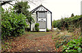
8
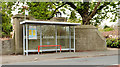
Bus stop and shelter, Greenisland (2013-1)
One of several bus stops along the Shore Road which will be affected by the roadworks. This one is on the Carrickfergus side of here Image
Image: © Albert Bridge
Taken: 4 May 2013
0.04 miles
9
The Shore Road, Jordanstown/Greenisland (7)
The Shore Road, close to Image, looking towards Carrickfergus.
Image: © Albert Bridge
Taken: 16 Feb 2012
0.04 miles
10
Vacant site, Jordanstown/Greenisland (1)
The site of two houses, on this part of the Shore Road Image, demolished to make way for the new road.
Image: © Albert Bridge
Taken: 16 Feb 2012
0.05 miles