IMAGES TAKEN NEAR TO
Hartley Hall Avenue, CARRICKFERGUS, BT38 8BA
Introduction
This page details the photographs taken nearby to Hartley Hall Avenue, BT38 8BA by members of the Geograph project.
The Geograph project started in 2005 with the aim of publishing, organising and preserving representative images for every square kilometre of Great Britain, Ireland and the Isle of Man.

There are currently over 7.5m images from over14,400 individuals and you can help contribute to the project by visiting https://www.geograph.org.uk
Image Map
Images are licensed for reuse under creativecommons.org/licenses/by-sa/2.0
Notes
- Clicking on the map will re-center to the selected point.
- The higher the marker number, the further away the image location is from the centre of the postcode.
Image Listing (46 Images Found)
Images are licensed for reuse under creativecommons.org/licenses/by-sa/2.0
Image
Details
Distance
1
Shorelands, Greenisland (6)
The Shorelands development seen from the Shore Road. The reserved line is at middle left.
Image: © Albert Bridge
Taken: 2 May 2012
0.12 miles
2
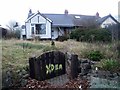
House marked for demolition
As part of the A2 upgrade, a number of houses are being demolished - as work begins this long abandoned house has been marked by workers for demolition.
Image: © Chris Johnston
Taken: 4 Mar 2013
0.17 miles
3
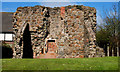
Castle Lug, Jordanstown/Greenisland
The remains of a tower house beside the Shore Road. Date of building unknown. The name comes from the Lugge family who were prominent in Carrickfergus in the 16th and 17th centuries.
Image: © Albert Bridge
Taken: 31 Mar 2011
0.17 miles
4
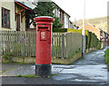
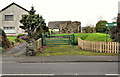
Pillar box, Greenisland
EIIR pillar box at Moyard Gardens in the Greenisland estate. The plate is missing but the number should be BT38 183.
Image: © Albert Bridge
Taken: 29 Dec 2013
0.17 miles
5
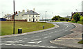
Shore Road
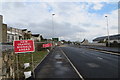
Warning signs approaching new A2 dual carriageway roundabout at Shorelands.
Image: © Robert Ashby
Taken: 28 Oct 2015
0.17 miles
6
Castle Lug, Jordanstown/Greenisland (2)
Castle Lug (Image – March 2011) with the existing single-carriageway Shore Road in the foreground. Acquisition of residential property, along the route, is far from complete. Many houses are still occupied.
Image: © Albert Bridge
Taken: 28 Feb 2012
0.18 miles
7
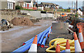
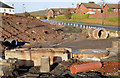
New roundabout, Shorelands - December 2013 (1)
A new roundabout under construction, on the Belfast side of Shorelands, where there is currently a “T” junction. When open it will be controlled by traffic lights.
Image: © Albert Bridge
Taken: 29 Dec 2013
0.18 miles
8
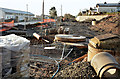
Road construction, Jordanstown/Greenisland (4)
The Shore Road under reconstruction, looking towards Carrickfergus, between Castle Lug and Shorelands.
Image: © Albert Bridge
Taken: 1 Dec 2013
0.18 miles
9
New retaining wall, Greenisland
A new retaining wall, on the Carrickfergus side of the entrance to Shorelands, where the existing houses are well above road level.
Image: © Albert Bridge
Taken: 29 Dec 2013
0.19 miles
10
New roundabout, Shorelands - December 2013 (2)
A new roundabout under construction, on the Belfast side of the entrance to Shorelands, where there is currently a “T” junction. When open it will be controlled by traffic lights.
Image: © Albert Bridge
Taken: 29 Dec 2013
0.19 miles