IMAGES TAKEN NEAR TO
Baird Avenue, CARRICKFERGUS, BT38 7XH
Introduction
This page details the photographs taken nearby to Baird Avenue, BT38 7XH by members of the Geograph project.
The Geograph project started in 2005 with the aim of publishing, organising and preserving representative images for every square kilometre of Great Britain, Ireland and the Isle of Man.

There are currently over 7.5m images from over14,400 individuals and you can help contribute to the project by visiting https://www.geograph.org.uk
Image Map
Images are licensed for reuse under creativecommons.org/licenses/by-sa/2.0
Notes
- Clicking on the map will re-center to the selected point.
- The higher the marker number, the further away the image location is from the centre of the postcode.
Image Listing (7 Images Found)
Images are licensed for reuse under creativecommons.org/licenses/by-sa/2.0
Image
Details
Distance
1
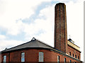
Chimney, the Barn Mills, Carrickfergus (1)
The truncated chimney on the Barn Mills Image seen from the north west. This link http://www.doeni.gov.uk/niea/built/buildview?id=10780&js=true suggests that the height was reduced after 1972. Image shows the view from the south west.
Image: © Albert Bridge
Taken: 28 Nov 2013
0.12 miles
2
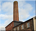
Chimney, the Barn Mills, Carrickfergus (2)
See Image The truncated chimney seen from the south west.
Image: © Albert Bridge
Taken: 28 Nov 2013
0.12 miles
3
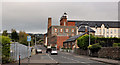
Taylor's Avenue, Carrickfergus (3)
See Image Well past the railway bridge, Taylor’s Avenue (looking outwards) from the corner of Prince William Way. The former Barn Mills Image is prominent on the right.
Image: © Albert Bridge
Taken: 14 Oct 2011
0.18 miles
4
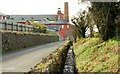
The Barn Mills, Carrickfergus
Taylor’s Avenue looking towards the town centre. The old Barn Mills (now apartments) is at upper left. The millrace is in the foreground. Built between 1840 and 1859. Now listed. For a full description see http://www.doeni.gov.uk/niea/built/buildview?id=10780&js=true
Image: © Albert Bridge
Taken: 22 Mar 2008
0.20 miles
5
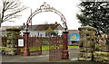
Gates, Victoria cemetery, Carrickfergus (1)
Wrought-iron gates and archway, at the entrance to Victoria Cemetery on the Victoria Road. It opened in 1904 with financial assistance from Hugh Legg Image Now much extended on the northern side. For more information see http://www.historyfromheadstones.com/index.php?displaygraveyardinfo&graveyard_name=Victoria%20Cemetery Continue to Image
Image: © Albert Bridge
Taken: 30 Nov 2011
0.22 miles
6
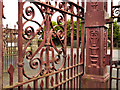
Gates, Victoria cemetery, Carrickfergus (2)
Image: © Albert Bridge
Taken: 30 Nov 2011
0.22 miles
7
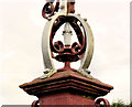
Gates, Victoria cemetery, Carrickfergus (3)
See Image Detail from a gatepost (looking out towards the Victoria Road).
Image: © Albert Bridge
Taken: 30 Nov 2011
0.22 miles