IMAGES TAKEN NEAR TO
Alexander Park, CARRICKFERGUS, BT38 7LL
Introduction
This page details the photographs taken nearby to Alexander Park, BT38 7LL by members of the Geograph project.
The Geograph project started in 2005 with the aim of publishing, organising and preserving representative images for every square kilometre of Great Britain, Ireland and the Isle of Man.

There are currently over 7.5m images from over14,400 individuals and you can help contribute to the project by visiting https://www.geograph.org.uk
Image Map
Images are licensed for reuse under creativecommons.org/licenses/by-sa/2.0
Notes
- Clicking on the map will re-center to the selected point.
- The higher the marker number, the further away the image location is from the centre of the postcode.
Image Listing (6 Images Found)
Images are licensed for reuse under creativecommons.org/licenses/by-sa/2.0
Image
Details
Distance
1
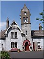
Shiels Almshouses, Carrickfergus
This institution was started up in the 1860s by Charles Shiels. Charles spent his life spending his money, using his spare time for the help of others. The Shiels institution is situated in several parts of Ireland. In Dungannon (on the circular road), Carrickfergus and Armagh.
There are large grounds with a lot of trees, bushes and flowers. In the summer if you drive or walk past you will see all the residents out on their deck-chairs catching he sun.
The Institution was built and finished in 1868, and the designs were by Charles Lanyon. But, as Charles had never built something as different, he hired a building agency to do this work for him. The design consists of a horse-shoe shaped terrace of houses, each one unique. In 1918 new houses were added.
When the houses were first built it was not just for pensioners. Anybody could live there, but only poor people did. Residents got allowances for coal, water and even to look after strangers! Any woman living without a child could be appointed to look after a man for a period of time. They were given money each week for food for him, beds and linen.
As there was no taps or plumbed water, people had to get water a different way. So, they used large tanks under-ground to store rain water that went down the drains, this was pumped through a pump in the yard. One of the pumps still exists but is no longer in use. The other was stolen two years ago.
In the supervisor's house there is a clock tower. You are able to get up to the clock, as I did. The clock was installed along with the building but the windows in the clock tower were not as the tower was open to the rain and wind. It has not been changed to an electronic clock but it is still run by weights and needs wound up every 7 days. The clock is completely accurate and has not been adjusted in nearly 3 years.
Shiels Institution: B : c.1868-70; Lanyon, Lynn and Lanyon of Belfast, architects. One of the five institutes built through the bequest of Charles Shiels (1782-1861) who left £90,000 to provide houses rent-free for widows and spinsters. The houses were built in five blocks (the others being at Armagh, Dublin, Dungannon and Killough) each having as its focus a warden's house with a main entrance and tall clock-tower. Using a full-blooded High-Victorian style the Lanyon firm created one of the town's most characterful and most delightfully situated buildings. The block is set back from the coast road behind a screen of mature trees and a gateway of polychrome and vigorously sculptural brickwork. Its layout, contrasting with the symmetry of earlier similar buildings (see No. 12e) is aggressively irregular, with the tower over the entrance at one end of the only part of the building which aligns with the road. From each side wings slant backwards through two angles thus enclosing three sides of a court. The doorway itself has attractive gilded lettering against a red background in the intersecting arch surround, which contrasts startlingly with the tower face. The walls, though now rendered grey, may originally have reflected the polychrome of the gateway. Certainly this would have been in keeping with the theatrical roof-scape above with its confusion of deep eaves, decoratively boarded gables, fish-scale banded tiling and tall chimney stacks. Above all rises the tower with pointed 'belfry' windows, clock face, bell-vents, shouldered gables and cast-iron cresting.
Ulster Architectural Heritage, Social Historic Buildings,
Groups of Buildings and Areas of Importance
in the Town of Carrickfergus (undated)
£90,000 in 1861 is worth £5,611,822.64 in today's money. Charles Shiels thought that he had left enough money to last forever, but this is not true. A few years ago, they had to sell some land to a builder as they did not have enough money to keep the institute going.
(Written by Adam Barnes, age 11, 2006)
Image: © Stephen Barnes
Taken: 5 Jun 2006
0.19 miles
2
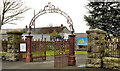
Gates, Victoria cemetery, Carrickfergus (1)
Wrought-iron gates and archway, at the entrance to Victoria Cemetery on the Victoria Road. It opened in 1904 with financial assistance from Hugh Legg Image Now much extended on the northern side. For more information see http://www.historyfromheadstones.com/index.php?displaygraveyardinfo&graveyard_name=Victoria%20Cemetery Continue to Image
Image: © Albert Bridge
Taken: 30 Nov 2011
0.24 miles
3
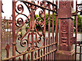
Gates, Victoria cemetery, Carrickfergus (2)
Image: © Albert Bridge
Taken: 30 Nov 2011
0.24 miles
4
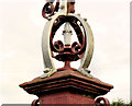
Gates, Victoria cemetery, Carrickfergus (3)
See Image Detail from a gatepost (looking out towards the Victoria Road).
Image: © Albert Bridge
Taken: 30 Nov 2011
0.24 miles
5
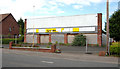
Former Downshire Motors, Carrickfergus
The former Downshire Motors site (there is another on the other side of the road), on the Larne Road, has been vacant for a number of years.
Image: © Albert Bridge
Taken: 6 May 2010
0.24 miles
6
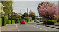
The Larne Road, Carrickfergus
The Larne Road at Downshire with a good display of cherry blossom on view. In the absence of high winds or heavy rain it seems to have lasted longer this year.
Image: © Albert Bridge
Taken: 6 May 2010
0.25 miles