IMAGES TAKEN NEAR TO
Taylors Avenue, CARRICKFERGUS, BT38 7HW
Introduction
This page details the photographs taken nearby to Taylors Avenue, BT38 7HW by members of the Geograph project.
The Geograph project started in 2005 with the aim of publishing, organising and preserving representative images for every square kilometre of Great Britain, Ireland and the Isle of Man.

There are currently over 7.5m images from over14,400 individuals and you can help contribute to the project by visiting https://www.geograph.org.uk
Image Map
Images are licensed for reuse under creativecommons.org/licenses/by-sa/2.0
Notes
- Clicking on the map will re-center to the selected point.
- The higher the marker number, the further away the image location is from the centre of the postcode.
Image Listing (3 Images Found)
Images are licensed for reuse under creativecommons.org/licenses/by-sa/2.0
Image
Details
Distance
1
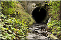
Culvert, Carrickfergus
A culvert, at Prince Andrew Way, across a small stream (not named on the 1:50,000 map) which rises in the higher ground to the north of Carrickfergus. It flows through Oakfield Glen http://www.woodlandtrust.org.uk/en/our-woods/Pages/about-this-wood.aspx?wood=5172 (behind me) before becoming the millrace seen in Image
Image: © Albert Bridge
Taken: 30 Nov 2011
0.02 miles
2
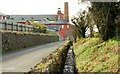
The Barn Mills, Carrickfergus
Taylor’s Avenue looking towards the town centre. The old Barn Mills (now apartments) is at upper left. The millrace is in the foreground. Built between 1840 and 1859. Now listed. For a full description see http://www.doeni.gov.uk/niea/built/buildview?id=10780&js=true
Image: © Albert Bridge
Taken: 22 Mar 2008
0.07 miles
3
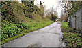
Lover's Lane, Carrickfergus (1)
Once a country loanin but now swallowed up by suburban growth and paralleled by Prince Andrew Way (behind the hedge on the left). There is a photograph of it, taken circa 1920, in “A Tour of East Antrim” – Doreen Corcoran, Friar’s Bush Press, 1990. Image shows the modern name sign.
Image: © Albert Bridge
Taken: 30 Nov 2011
0.17 miles