IMAGES TAKEN NEAR TO
Taylors Avenue, CARRICKFERGUS, BT38 7HT
Introduction
This page details the photographs taken nearby to Taylors Avenue, BT38 7HT by members of the Geograph project.
The Geograph project started in 2005 with the aim of publishing, organising and preserving representative images for every square kilometre of Great Britain, Ireland and the Isle of Man.

There are currently over 7.5m images from over14,400 individuals and you can help contribute to the project by visiting https://www.geograph.org.uk
Image Map
Images are licensed for reuse under creativecommons.org/licenses/by-sa/2.0
Notes
- Clicking on the map will re-center to the selected point.
- The higher the marker number, the further away the image location is from the centre of the postcode.
Image Listing (77 Images Found)
Images are licensed for reuse under creativecommons.org/licenses/by-sa/2.0
Image
Details
Distance
1
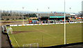
Taylor's Avenue football ground, Carrickfergus
The home of Carrick Rangers.
Image: © Albert Bridge
Taken: 3 Mar 2010
0.06 miles
2
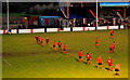
Taylor's Avenue football ground, Carrickfergus (2)
See Image A few minutes into the second half with Carrick Rangers (orange) defending the goal to the left, under floodlights, against Larne. Carrick won 3-0.
Image: © Albert Bridge
Taken: 1 Jan 2011
0.07 miles
3
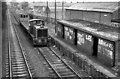
Barn station, Carrickfergus (3)
See Image A scene not untypical of the Larne line in the early/mid-1980’s. Diesel-hydraulic locomotive no 1 is passing the closed and vandalised Barn station with some empty wagons which had been used to discharge rails between Ballycarry and Magheramorne. Image shows the same view in 2006 after the station had been removed.
Image: © Albert Bridge
Taken: 19 Mar 1984
0.08 miles
4
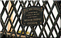
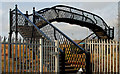
Railway footbridge, Barn, Carrickfergus (4)
See Image The plate, on the Carrickfergus/Belfast side of the bridge, showing that it was made by the Saracen Foundry, Glasgow.
Image: © Albert Bridge
Taken: 16 Jan 2011
0.08 miles
5
Railway footbridge, Barn, Carrickfergus (3)
Image: © Albert Bridge
Taken: 16 Jan 2011
0.08 miles
6
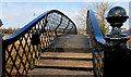
Railway footbridge, Barn, Carrickfergus (1)
With the closure of Barn station Image in 1977, the footbridge’s only remaining function is to avoid the “long” way round up and down Taylor’s Avenue Image and Image The lattice bridge is similar to that at Whitehead station Image This view is from the road bridge Image at Taylor’s Avenue. Continue to Image
Image: © Albert Bridge
Taken: 16 Jan 2011
0.08 miles
7
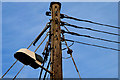
Street light, Barn, Carrickfergus
A street light, attached to a telegraph pole, close to the railway footbridge Image
Image: © Albert Bridge
Taken: 16 Jan 2011
0.08 miles
8
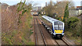
Train, Barn, Carrickfergus (2 in 2013)
A three-car C4K set (4014) passing the site of Barn station with the 11.45 Whitehead - Belfast Gt Victoria Street.
Image: © Albert Bridge
Taken: 28 Nov 2013
0.08 miles
9
Railway footbridge, Barn, Carrickfergus (2)
See Image The bridge, from street level, at what was the entrance to the up (staggered) platform at Barn station. Continue to Image
Image: © Albert Bridge
Taken: 16 Jan 2011
0.08 miles
10
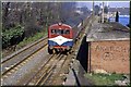
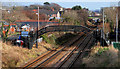
Barn railway station
See Image Barn was one of three stations on the Belfast – Larne line with staggered platforms. It was very close to Downshire station Image and closed in 1977. The 16.10 Larne Town – York Road is passing the disused up platform.
Image: © Albert Bridge
Taken: 5 Apr 1980
0.09 miles