IMAGES TAKEN NEAR TO
Taylors Avenue, CARRICKFERGUS, BT38 7HL
Introduction
This page details the photographs taken nearby to Taylors Avenue, BT38 7HL by members of the Geograph project.
The Geograph project started in 2005 with the aim of publishing, organising and preserving representative images for every square kilometre of Great Britain, Ireland and the Isle of Man.

There are currently over 7.5m images from over14,400 individuals and you can help contribute to the project by visiting https://www.geograph.org.uk
Image Map
Images are licensed for reuse under creativecommons.org/licenses/by-sa/2.0
Notes
- Clicking on the map will re-center to the selected point.
- The higher the marker number, the further away the image location is from the centre of the postcode.
Image Listing (7 Images Found)
Images are licensed for reuse under creativecommons.org/licenses/by-sa/2.0
Image
Details
Distance
1
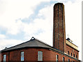
Chimney, the Barn Mills, Carrickfergus (1)
The truncated chimney on the Barn Mills Image seen from the north west. This link http://www.doeni.gov.uk/niea/built/buildview?id=10780&js=true suggests that the height was reduced after 1972. Image shows the view from the south west.
Image: © Albert Bridge
Taken: 28 Nov 2013
0.04 miles
2
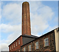
Chimney, the Barn Mills, Carrickfergus (2)
See Image The truncated chimney seen from the south west.
Image: © Albert Bridge
Taken: 28 Nov 2013
0.04 miles
3
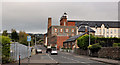
Taylor's Avenue, Carrickfergus (3)
See Image Well past the railway bridge, Taylor’s Avenue (looking outwards) from the corner of Prince William Way. The former Barn Mills Image is prominent on the right.
Image: © Albert Bridge
Taken: 14 Oct 2011
0.07 miles
4
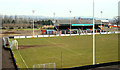
Taylor's Avenue football ground, Carrickfergus
The home of Carrick Rangers.
Image: © Albert Bridge
Taken: 3 Mar 2010
0.22 miles
5
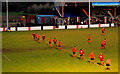
Taylor's Avenue football ground, Carrickfergus (2)
See Image A few minutes into the second half with Carrick Rangers (orange) defending the goal to the left, under floodlights, against Larne. Carrick won 3-0.
Image: © Albert Bridge
Taken: 1 Jan 2011
0.22 miles
6
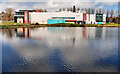
Carrickfergus leisure centre
The leisure centre (“Amphitheatre”), at Prince William Way, seen from across the old mill ponds Image Hard to believe that it opened 30 years ago.
Image: © Albert Bridge
Taken: 1 Apr 2010
0.23 miles
7
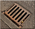
"GH Laud" grating cover, Carrickfergus
A grating cover, at Prince William Way opposite the ambulance station, bearing the name “GH Laud & Son”. A visitor to the site has contacted me to say that the business was based in Bourne, Lincs http://www.geograph.org.uk/gridref/TF1119 and traded until the late 1980’s. Trading ceased following the death of the owner.
Image: © Albert Bridge
Taken: 14 Oct 2011
0.24 miles