IMAGES TAKEN NEAR TO
Joymount, CARRICKFERGUS, BT38 7DQ
Introduction
This page details the photographs taken nearby to Joymount, BT38 7DQ by members of the Geograph project.
The Geograph project started in 2005 with the aim of publishing, organising and preserving representative images for every square kilometre of Great Britain, Ireland and the Isle of Man.

There are currently over 7.5m images from over14,400 individuals and you can help contribute to the project by visiting https://www.geograph.org.uk
Image Map
Images are licensed for reuse under creativecommons.org/licenses/by-sa/2.0
Notes
- Clicking on the map will re-center to the selected point.
- The higher the marker number, the further away the image location is from the centre of the postcode.
Image Listing (549 Images Found)
Images are licensed for reuse under creativecommons.org/licenses/by-sa/2.0
Image
Details
Distance
1
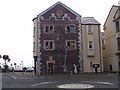
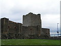
Painted building in Carrickfergus
near the castle
Image: © william craig
Taken: Unknown
0.00 miles
2
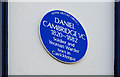
Daniel Cambridge VC plaque, Carrickfergus
Plaque, at High Street, commemorating Daniel Cambridge VC http://www.ulsterhistory.co.uk/cambridge.htm.
Image: © Albert Bridge
Taken: 1 Apr 2010
0.00 miles
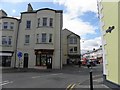
3

Barnados / Bank of Ireland, Carrickfergus
They are located at High Street
Image: © Kenneth Allen
Taken: 14 May 2010
0.01 miles
4

Ulster Bank / Pyper Property Rentals, Carrickfergus
High Street is in the middle of renovations at present
Image: © Kenneth Allen
Taken: 14 May 2010
0.01 miles
5
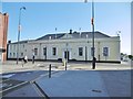
Carrickfergus Town Hall
On Joymount; built in 1779 on the site of a friary; later residence, then courthouse and gaol in previous existences.
Image: © Mike Faherty
Taken: 2 Jul 2018
0.01 miles
6
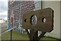
Pillory, Carrickfergus
Long before Belfast was even a crossing point on the river, Carrickfergus was the principal legal and administrative centre for Co Antrim. It had the castle and military garrison, courthouse and jail and was the place where executions took place. This (reproduction) pillory is a reminder of how miscreants were dealt with in the 16th century (before the invention of the safari holiday). See also Image
Image: © Albert Bridge
Taken: 28 Dec 2008
0.01 miles
7
Rayz, Carrickfergus
It is located at Joymount
Image: © Kenneth Allen
Taken: 14 May 2010
0.01 miles
8
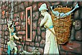
Mural, Carrickfergus
This is part of a mural (which can be seen in the background in Image) depicting a scene from the life of everyday folk in 16th century Carrickfergus.
Image: © Albert Bridge
Taken: 28 Dec 2008
0.01 miles
9
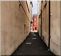
Purity Lane, Carrickfergus
Narrow thoroughfare (not shown on the Google map), within the walls, running from the Marine Highway to High Street (background).
Image: © Albert Bridge
Taken: 5 Sep 2010
0.01 miles