IMAGES TAKEN NEAR TO
Mournebeg Way, NEWTOWNABBEY, BT37 9LX
Introduction
This page details the photographs taken nearby to Mournebeg Way, BT37 9LX by members of the Geograph project.
The Geograph project started in 2005 with the aim of publishing, organising and preserving representative images for every square kilometre of Great Britain, Ireland and the Isle of Man.

There are currently over 7.5m images from over14,400 individuals and you can help contribute to the project by visiting https://www.geograph.org.uk
Image Map
Images are licensed for reuse under creativecommons.org/licenses/by-sa/2.0
Notes
- Clicking on the map will re-center to the selected point.
- The higher the marker number, the further away the image location is from the centre of the postcode.
Image Listing (3 Images Found)
Images are licensed for reuse under creativecommons.org/licenses/by-sa/2.0
Image
Details
Distance
1
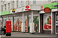
Pillar box, Cloughfern, Newtownabbey
EIIR pillar box (BT37 637) at Abbot’s Cross post office on the Doagh Road.
Image: © Albert Bridge
Taken: 16 May 2012
0.12 miles
2
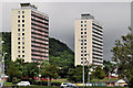
Carncoole House and Glencoole House, Rathcoole, Newtownabbey
Carncoole House (left) and Glencoole House are two of four 15 storey tower blocks, in the Rathcoole estate, built in the mid-1960’s. They can be seen, on the left, in this elevated view Image
Image: © Albert Bridge
Taken: 9 Jun 2012
0.21 miles
3
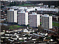
Flats, Rathcoole
Multi-storey flats at Rathcoole in Newtownabbey as seen from Cave Hill. Known locally as the 'Multies' - see also Image
Image: © Rossographer
Taken: 19 Dec 2009
0.22 miles