IMAGES TAKEN NEAR TO
Green Walk, NEWTOWNABBEY, BT37 9AB
Introduction
This page details the photographs taken nearby to Green Walk, BT37 9AB by members of the Geograph project.
The Geograph project started in 2005 with the aim of publishing, organising and preserving representative images for every square kilometre of Great Britain, Ireland and the Isle of Man.

There are currently over 7.5m images from over14,400 individuals and you can help contribute to the project by visiting https://www.geograph.org.uk
Image Map
Images are licensed for reuse under creativecommons.org/licenses/by-sa/2.0
Notes
- Clicking on the map will re-center to the selected point.
- The higher the marker number, the further away the image location is from the centre of the postcode.
Image Listing (11 Images Found)
Images are licensed for reuse under creativecommons.org/licenses/by-sa/2.0
Image
Details
Distance
1
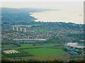
Northern Side of Belfast Lough
Taken from the top of Cave Hill, showing the Northern Shores on Belfast Lough from North Belfast up to Kilroot Power Station.
In the Lough can just be seen the mussel dredger 'Emerald Gratia' http://www.geograph.org.uk/search.php?i=1801055
Image: © Rossographer
Taken: 20 Oct 2007
0.08 miles
2
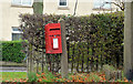
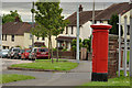
Letter box, Rushpark, Newtownabbey
Post-mounted EIIR box (BT37 766) on the Doagh Road.
Image: © Albert Bridge
Taken: 13 Nov 2012
0.14 miles
3
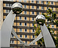
"Strength" sculpture, Rathcoole, Newtownabbey
See Image A sculpture, by Gary Armstrong, entitled “Strength”, representing “the strength of the family unit”, close to The Diamond. Monkscoole House Image is in the background.
Image: © Albert Bridge
Taken: 9 Jun 2012
0.18 miles
4
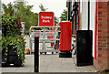
Pillar box, Rathcoole, Newtownabbey
EIIR pillar box (BT37 460), outside the post office, at Rathmullan Drive.
Image: © Albert Bridge
Taken: 9 Jun 2012
0.18 miles
5
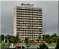
Monkscoole House, Rathcoole, Newtownabbey
Monkscoole House is one of four 15 storey tower blocks, in the Rathcoole estate, built in the mid-1960’s. It can be seen, on the right, in this elevated view Image
Image: © Albert Bridge
Taken: 9 Jun 2012
0.20 miles
6
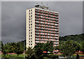
Abbotscoole House, Rathcoole, Newtownabbey
Abbotscoole House is one of four 15 storey tower blocks, in the Rathcoole estate, built in the mid-1960’s. It can be seen, second right, in this elevated view Image
Image: © Albert Bridge
Taken: 9 Jun 2012
0.20 miles
7
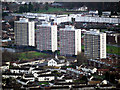
Flats, Rathcoole
Multi-storey flats at Rathcoole in Newtownabbey as seen from Cave Hill. Known locally as the 'Multies' - see also Image
Image: © Rossographer
Taken: 19 Dec 2009
0.20 miles
8
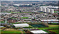
Rathcoole
The Rathcoole estate as seen from Cave Hill. Built in the 1950s as homes for those displaced by the demolition of inner city housing in the centre of Belfast. See http://en.wikipedia.org/wiki/Rathcoole_(Belfast) for an overview of the areas history.
Image: © Rossographer
Taken: 19 Dec 2009
0.22 miles
9
Pillar box, Rathcoole, Newtownabbey
EIIR pillar box (no number visible but it should be BT37 247) at Rathcoole Drive, near Ardfarn Close.
Image: © Albert Bridge
Taken: 9 Jun 2012
0.22 miles
10
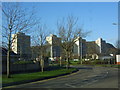
The 'Multies'
The four Multi-storey towerblocks situated at the heart of Rathcoole Estate.
Image: © Gary Thompson
Taken: 12 Jan 2009
0.22 miles