IMAGES TAKEN NEAR TO
Moylinney Court, NEWTOWNABBEY, BT37 0UY
Introduction
This page details the photographs taken nearby to Moylinney Court, BT37 0UY by members of the Geograph project.
The Geograph project started in 2005 with the aim of publishing, organising and preserving representative images for every square kilometre of Great Britain, Ireland and the Isle of Man.

There are currently over 7.5m images from over14,400 individuals and you can help contribute to the project by visiting https://www.geograph.org.uk
Image Map
Images are licensed for reuse under creativecommons.org/licenses/by-sa/2.0
Notes
- Clicking on the map will re-center to the selected point.
- The higher the marker number, the further away the image location is from the centre of the postcode.
Image Listing (14 Images Found)
Images are licensed for reuse under creativecommons.org/licenses/by-sa/2.0
Image
Details
Distance
1
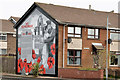
World War 1 mural, Monkstown, Newtownabbey (1)
A mural, between Cashel Close and Cashel Drive on the Monkstown Road, commemorating the dead of World War 1. Image shows a detail.
Image: © Albert Bridge
Taken: 16 Apr 2014
0.12 miles
2
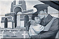
World War 1 mural, Monkstown, Newtownabbey (2)
See Image A detail from the mural. http://en.wikipedia.org/wiki/Thiepval_Memorial and http://www.cwgc.org/find-a-cemetery/cemetery/80800/THIEPVAL%20MEMORIAL is in the background.
Image: © Albert Bridge
Taken: 16 Apr 2014
0.12 miles
3

Pillar box, Monkstown
EIIR pillar box, outside this shop Image, on the Jordanstown Road.
Image: © Albert Bridge
Taken: 31 Aug 2011
0.13 miles
4
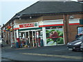
Spar Shop
The Spar shop on the Jordanstown Road
Image: © Albert Thompson
Taken: 31 Dec 2008
0.14 miles
5
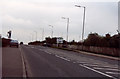
Old Carrick Road, Newtownabbey
Taken 1999, shows the entrance to The Brambles, facing Greenisland/Carrickfergus
Image: © Stephen Barnes
Taken: 27 Oct 1999
0.15 miles
6
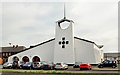
Abbey Presbyterian church, Monkstown, Newtownabbey (1)
A church http://www.abbeypresbyterian.org.uk/ , at the corner of the Monkstown Road (foreground) and the Jordanstown Road, built in what might be called the “New Mexico” style of architecture. Date of building unknown but probably a contemporary of the nearby Monkstown housing estate. Image shows a side view from the Jordanstown Road.
Image: © Albert Bridge
Taken: 16 Apr 2014
0.18 miles
7
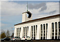
Abbey Presbyterian church, Monkstown, Newtownabbey (2)
Image: © Albert Bridge
Taken: 16 Apr 2014
0.18 miles
8
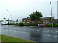
Monkstown Village Centre
Monkstown shops at the junction of the Monkstown Road and Jordanstown Road
Image: © Robert Ashby
Taken: 17 Jun 2013
0.19 miles
9
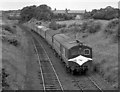
Train south of Monkstown station
Ulster Transport Authority (UTA) built 70-class No. 77 "River Braid" is south of the former Monkstown station as it heads the 12.00 Londonderry/Derry - Belfast (York Road) passenger service.
Image: © The Carlisle Kid
Taken: 31 Jul 1977
0.20 miles
10
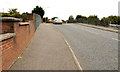
Railway bridge, Monkstown (1)
The bridge carrying the Jordanstown Road over the Belfast – Londonderry railway. It dates from the building of the direct (loop) line from Bleach Green Image to Monkstown Image (opened in 1934). The view is towards Jordanstown. Image shows the plaques recording the dates of building and widening.
Image: © Albert Bridge
Taken: 31 Aug 2011
0.22 miles