IMAGES TAKEN NEAR TO
Meadow View, NEWTOWNABBEY, BT37 0US
Introduction
This page details the photographs taken nearby to Meadow View, BT37 0US by members of the Geograph project.
The Geograph project started in 2005 with the aim of publishing, organising and preserving representative images for every square kilometre of Great Britain, Ireland and the Isle of Man.

There are currently over 7.5m images from over14,400 individuals and you can help contribute to the project by visiting https://www.geograph.org.uk
Image Map
Images are licensed for reuse under creativecommons.org/licenses/by-sa/2.0
Notes
- Clicking on the map will re-center to the selected point.
- The higher the marker number, the further away the image location is from the centre of the postcode.
Image Listing (2 Images Found)
Images are licensed for reuse under creativecommons.org/licenses/by-sa/2.0
Image
Details
Distance
1
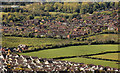
Green belt, Greenisland/Monkstown
The view from Knockagh war memorial Image of some undeveloped fields, off the Old Carrick Road, between Monkstown, Newtownabbey (top) and Greenisland, Carrickfergus (bottom). The Farm Lodge development Image is at the bottom.
Image: © Albert Bridge
Taken: 16 May 2012
0.16 miles
2

Ballast Wagons approaching
RPSI 3 and ballast wagons approaching Meadowbank Farm Crossing on the recently relaid unballasted track
Image: © Wilson Adams
Taken: 10 Aug 2005
0.23 miles