IMAGES TAKEN NEAR TO
Shore Road, NEWTOWNABBEY, BT37 0ST
Introduction
This page details the photographs taken nearby to Shore Road, BT37 0ST by members of the Geograph project.
The Geograph project started in 2005 with the aim of publishing, organising and preserving representative images for every square kilometre of Great Britain, Ireland and the Isle of Man.

There are currently over 7.5m images from over14,400 individuals and you can help contribute to the project by visiting https://www.geograph.org.uk
Image Map
Images are licensed for reuse under creativecommons.org/licenses/by-sa/2.0
Notes
- Clicking on the map will re-center to the selected point.
- The higher the marker number, the further away the image location is from the centre of the postcode.
Image Listing (26 Images Found)
Images are licensed for reuse under creativecommons.org/licenses/by-sa/2.0
Image
Details
Distance
1
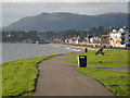
Shore Road and Cavehill
A view of the Shore Road at Whiteabbey with the Cavehill in the background. The photograph is taken from Loughshore Park.
Image: © Albert Thompson
Taken: 28 Dec 2008
0.04 miles
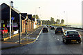
2
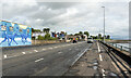
The A2 Shore Road at Jordanstown
The A2 at Jordanstown.
Image: © Rossographer
Taken: 27 Aug 2024
0.04 miles
3
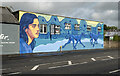
Mural, Jordanstown
Mural by Lidia Cao https://www.instagram.com/lidia.cao/ on the A2 at Jordanstown.
Image: © Rossographer
Taken: 27 Aug 2024
0.07 miles
4
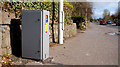
Traffic counter, Jordanstown
A solar-powered traffic, counter on the Shore Road, on the Carrickfergus side of Image
Image: © Albert Bridge
Taken: 31 Mar 2011
0.09 miles
5
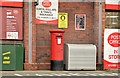
Pillar box BT37 256, Whiteabbey
EIIR pillar box (BT37 256), at Whiteabbey Spar and post office, on the Shore Road.
Image: © Albert Bridge
Taken: 30 Mar 2014
0.10 miles
6

Flower beds at Whiteabbey
One of several flowerbeds beside the Shore Road at Whiteabbey.
Image: © Albert Bridge
Taken: 21 Jul 2008
0.10 miles
8
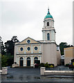
Whiteabbey Presbyterian Church
Presbyterian church located on the Shore Road, Whiteabbey.
Image: © Rossographer
Taken: 14 Jul 2010
0.10 miles
9
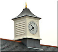
Lantern and Canavan clock, Whiteabbey
A lantern, incorporating a Canavan clock (adjusted for British Summer Time), on the block of shops between the two lines of the Shore Road.
Image: © Albert Bridge
Taken: 30 Mar 2014
0.10 miles
10
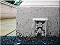
Flush Bracket, Whiteabbey
Flush bracket located on the north-eastern tip of Whiteabbey Presbyterian Church Image
The bracket has been partially buried by tarmac but the number on the bracket is OSBM 3390.
The mark is 3.90 metres above MSL.
A flush bracket is a type of bench mark set onto the face of a building. See also http://www.geograph.org.uk/search.php?i=11037856 for many other examples I have found.
Image: © Rossographer
Taken: 14 Jul 2010
0.11 miles