IMAGES TAKEN NEAR TO
Dunsona Park, NEWTOWNABBEY, BT37 0RN
Introduction
This page details the photographs taken nearby to Dunsona Park, BT37 0RN by members of the Geograph project.
The Geograph project started in 2005 with the aim of publishing, organising and preserving representative images for every square kilometre of Great Britain, Ireland and the Isle of Man.

There are currently over 7.5m images from over14,400 individuals and you can help contribute to the project by visiting https://www.geograph.org.uk
Image Map
Images are licensed for reuse under creativecommons.org/licenses/by-sa/2.0
Notes
- Clicking on the map will re-center to the selected point.
- The higher the marker number, the further away the image location is from the centre of the postcode.
Image Listing (3 Images Found)
Images are licensed for reuse under creativecommons.org/licenses/by-sa/2.0
Image
Details
Distance
1
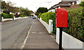
Letter box, Jordanstown
Post-mounted EIIR letter box in Gleneden Park, off the Jordanstown Road.
Image: © Albert Bridge
Taken: 31 Aug 2011
0.20 miles
2
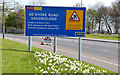
Road construction contract sign, Whiteabbey/Jordanstown (2013)
The sign, on the Shore Road, approaching the Loughshore Park, giving information about the reconstruction of the road between Jordanstown and Greenisland.
Image: © Albert Bridge
Taken: 4 May 2013
0.24 miles
3

Flower beds at Whiteabbey
One of several flowerbeds beside the Shore Road at Whiteabbey.
Image: © Albert Bridge
Taken: 21 Jul 2008
0.25 miles