IMAGES TAKEN NEAR TO
Shore Road, NEWTOWNABBEY, BT37 0PY
Introduction
This page details the photographs taken nearby to Shore Road, BT37 0PY by members of the Geograph project.
The Geograph project started in 2005 with the aim of publishing, organising and preserving representative images for every square kilometre of Great Britain, Ireland and the Isle of Man.

There are currently over 7.5m images from over14,400 individuals and you can help contribute to the project by visiting https://www.geograph.org.uk
Image Map
Images are licensed for reuse under creativecommons.org/licenses/by-sa/2.0
Notes
- Clicking on the map will re-center to the selected point.
- The higher the marker number, the further away the image location is from the centre of the postcode.
Image Listing (85 Images Found)
Images are licensed for reuse under creativecommons.org/licenses/by-sa/2.0
Image
Details
Distance
1
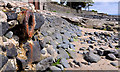
Rusty pipe, Jordanstown
A rusty pipe, emerging from its passage under the Shore Road, into the open on the loughshore at Jordanstown. It has the appearance of the disused outlet from a storm drain.
Image: © Albert Bridge
Taken: 6 Jun 2011
0.02 miles
2
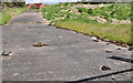
Former Newtownabbey Boat Club, Jordanstown (3)
Part of the vacant site seen through the gap in Image The gate’s shadow is visible at bottom right.
Image: © Albert Bridge
Taken: 6 Jun 2011
0.02 miles
3
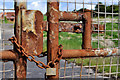
Former Newtownabbey Boat Club, Jordanstown (2)
A close look at the rusty gate seen in the background of Image
Image: © Albert Bridge
Taken: 6 Jun 2011
0.03 miles
4
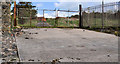
Former Newtownabbey Boat Club, Jordanstown (1)
A slipway leading from the site to the loughshore and Belfast Lough.
Image: © Albert Bridge
Taken: 6 Jun 2011
0.03 miles
5
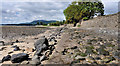
The loughshore, Jordanstown/Greenisland (1)
A part of the shore of Belfast Lough, well hidden from the Shore Road by housing and only seen by the few who are prepared to walk (tides permitting) from the Loughshore Park, Jordanstown (middle background).
Image: © Albert Bridge
Taken: 6 Jun 2011
0.03 miles
6
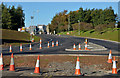
Road construction, Jordanstown (2)
The new roundabout, under construction, at the entrance to the University of Ulster.
Image: © Albert Bridge
Taken: 10 Nov 2013
0.03 miles
7
University entrance, Jordanstown (2013-1)
The entrance to the University of Ulster Image on the Shore Road – nothing visible yet at this junction which is due to become a roundabout.
Image: © Albert Bridge
Taken: 4 May 2013
0.03 miles
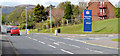
8
University entrance, Jordanstown, Newtownabbey (2)
The entrance, from the Shore Road, to the University of Ulster Image (looking towards Belfast). This junction is due to become a roundabout and will be, to all intents and purposes, the start of the new road. The grassed area is the reserved line.
Image: © Albert Bridge
Taken: 16 Feb 2012
0.03 miles
9
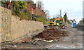
Road construction, Jordanstown (5)
Construction of the new road at the entrance to the University of Ulster, looking towards Carrickfergus, along what had been the reserved line. There is a new stone-faced retaining wall (left) below the houses in Langley Hall.
Image: © Albert Bridge
Taken: 1 Dec 2013
0.04 miles
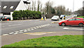
10
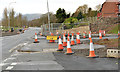
Road construction, Jordanstown (6)
Part of the new roundabout (not yet in use), looking towards Belfast, at the entrance to the University of Ulster.
Image: © Albert Bridge
Taken: 1 Dec 2013
0.04 miles