IMAGES TAKEN NEAR TO
Shore Road, NEWTOWNABBEY, BT37 0PX
Introduction
This page details the photographs taken nearby to Shore Road, BT37 0PX by members of the Geograph project.
The Geograph project started in 2005 with the aim of publishing, organising and preserving representative images for every square kilometre of Great Britain, Ireland and the Isle of Man.

There are currently over 7.5m images from over14,400 individuals and you can help contribute to the project by visiting https://www.geograph.org.uk
Image Map
Images are licensed for reuse under creativecommons.org/licenses/by-sa/2.0
Notes
- Clicking on the map will re-center to the selected point.
- The higher the marker number, the further away the image location is from the centre of the postcode.
Image Listing (93 Images Found)
Images are licensed for reuse under creativecommons.org/licenses/by-sa/2.0
Image
Details
Distance
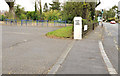
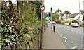
1
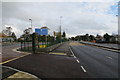
Shore road
Entrance to Belfast High school and the now completed A2 dual carriageway to Carrickfergus.
Image: © Robert Ashby
Taken: 28 Oct 2015
0.05 miles
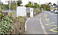
2
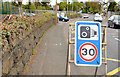
"Speed camera" sign, Jordanstown/Greenisland (2013-1)
There is a 30mph speed limit, on the Shore Road, over the entire length of the roadworks. This enforcement sign is just before the entrance to Belfast High School, in the outward direction.
Image: © Albert Bridge
Taken: 4 May 2013
0.07 miles
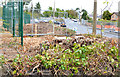
3
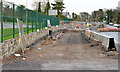
Road construction, Jordanstown/Greenisland (1)
The Shore Road, looking towards Carrickfergus, under reconstruction outside Belfast High School. The works include a new wall and fence (left).
Image: © Albert Bridge
Taken: 1 Dec 2013
0.07 miles
4
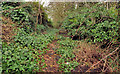
Lane, Jordanstown, Newtownabbey
A lane, (background in Image), off the Shore Road, close to Langley Hall which will disappear to make way for the new road.
Image: © Albert Bridge
Taken: 16 Feb 2012
0.07 miles
5
School entrance, Jordanstown, Newtownabbey
The entrance to Belfast High School (during the mid-term break) looking towards Carrickfergus. This will be almost unrecognisable once work starts on the new road.
Image: © Albert Bridge
Taken: 16 Feb 2012
0.08 miles
6
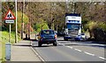
The Shore Road, Jordanstown
The Belfast – Carrickfergus road is a mixture of motorway, dual carriageway and four-lanes. The 1½ miles between Jordanstown and Greenisland remains a twisting single carriageway. Various schemes have been proposed (and rejected) over the last 30+ years. The latest scheme (which will be the subject of a public enquiry) envisages a dual carriageway (partly on a new line). The road carries around 30,000 vehicles daily.
Image: © Albert Bridge
Taken: 12 Mar 2008
0.08 miles
7
Belfast High School, Jordanstown/Greenisland (2013-1)
The Shore Road, looking towards Carrickfergus, from the end of this lane Image Some of the trees in what were the grounds of Belfast High School have been felled (foreground).
Image: © Albert Bridge
Taken: 4 May 2013
0.08 miles
8
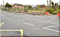
The Shore Road, Jordanstown/Greenisland (2013-2)
The Shore Road, opposite here Image, where some gardens are in the process of being removed.
Image: © Albert Bridge
Taken: 4 May 2013
0.08 miles
9
The Shore Road, Jordanstown/Greenisland (6)
The Shore Road (looking towards Carrickfergus) immediately past the entrance to Belfast High School Image, just before Silverstream Banks.
Image: © Albert Bridge
Taken: 16 Feb 2012
0.08 miles
10
Belfast High School, Jordanstown/Greenisland (2013-2)
Belfast High School at the entrance/exit on the Shore Road. Some trees have been removed (to the left of the gatepost).
Image: © Albert Bridge
Taken: 4 May 2013
0.08 miles