IMAGES TAKEN NEAR TO
Glenville Court, NEWTOWNABBEY, BT37 0GX
Introduction
This page details the photographs taken nearby to Glenville Court, BT37 0GX by members of the Geograph project.
The Geograph project started in 2005 with the aim of publishing, organising and preserving representative images for every square kilometre of Great Britain, Ireland and the Isle of Man.

There are currently over 7.5m images from over14,400 individuals and you can help contribute to the project by visiting https://www.geograph.org.uk
Image Map
Images are licensed for reuse under creativecommons.org/licenses/by-sa/2.0
Notes
- Clicking on the map will re-center to the selected point.
- The higher the marker number, the further away the image location is from the centre of the postcode.
Image Listing (39 Images Found)
Images are licensed for reuse under creativecommons.org/licenses/by-sa/2.0
Image
Details
Distance
1
"Welcome to Whiteabbey"
A “Welcome to Whiteabbey” sign beside the Glenville Road.
Image: © Albert Bridge
Taken: 18 Feb 2014
0.04 miles
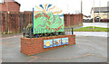
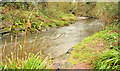
2
The Glen Park, Whiteabbey (1)
Part of the park, near Glenville Park, before it enters the wooded part of The Glen.
Image: © Albert Bridge
Taken: 1 Feb 2012
0.05 miles
3
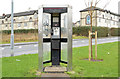
KX300 telephone box, Whiteabbey
A (triangular) KX300 telephone box, on the Glenville Road, near Glenview Gardens.
Image: © Albert Bridge
Taken: 18 Feb 2014
0.09 miles
4
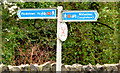
National Cycle Network signs, Whiteabbey
Signposts for National Cycle Network route 93 http://www.geograph.org.uk/tagged/National+cycle+route+93#photo=2739833 at the entrance to the Glen Park on the Glenville Road.
Image: © Albert Bridge
Taken: 18 Feb 2014
0.10 miles
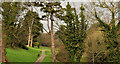
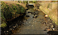
5
The Three Mile Water, Whiteabbey (4)
The Three Mile Water, almost at the end of its journey through the Glen Park, shortly before flowing under the Shore Road Image
Image: © Albert Bridge
Taken: 18 Feb 2014
0.11 miles
6

Whiteabbey Presbyterian church
Whiteabbey Presbyterian church was built in 1866. It was restored after being destroyed by fire in the early part of this century. This is the tower.
Image: © Albert Bridge
Taken: 22 Dec 2007
0.14 miles
7
The Three Mile Water, Whiteabbey (1)
The end of the Three Mile Water, at the Shore Road, Whiteabbey. It enters Belfast Lough on the other side of the road. This is not part of the park but is included in the shared description for ease of reference.
Image: © Albert Bridge
Taken: 1 Feb 2012
0.16 miles
8
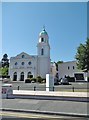
Whiteabbey, church
Whiteabbey Presbyterian Church, on Shore Road (former A2): http://www.whiteabbey.org/
Image: © Mike Faherty
Taken: 2 Jul 2018
0.16 miles
9
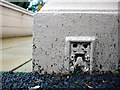
Flush Bracket, Whiteabbey
Flush bracket located on the north-eastern tip of Whiteabbey Presbyterian Church Image
The bracket has been partially buried by tarmac but the number on the bracket is OSBM 3390.
The mark is 3.90 metres above MSL.
A flush bracket is a type of bench mark set onto the face of a building. See also http://www.geograph.org.uk/search.php?i=11037856 for many other examples I have found.
Image: © Rossographer
Taken: 14 Jul 2010
0.16 miles
10
Shore Road, Whiteabbey
The road signs are small compared with the hoarding for new apartments
Image: © David Smith
Taken: 19 Sep 2012
0.17 miles