IMAGES TAKEN NEAR TO
Twinburn Hill, NEWTOWNABBEY, BT37 0EJ
Introduction
This page details the photographs taken nearby to Twinburn Hill, BT37 0EJ by members of the Geograph project.
The Geograph project started in 2005 with the aim of publishing, organising and preserving representative images for every square kilometre of Great Britain, Ireland and the Isle of Man.

There are currently over 7.5m images from over14,400 individuals and you can help contribute to the project by visiting https://www.geograph.org.uk
Image Map
Images are licensed for reuse under creativecommons.org/licenses/by-sa/2.0
Notes
- Clicking on the map will re-center to the selected point.
- The higher the marker number, the further away the image location is from the centre of the postcode.
Image Listing (16 Images Found)
Images are licensed for reuse under creativecommons.org/licenses/by-sa/2.0
Image
Details
Distance
1
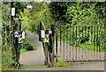
Gate, Monkstown, Newtownabbey
National Cycle Network Route no 93 passes through the park. This gate is close to the Hawthorne Road.
Image: © Albert Bridge
Taken: 10 Aug 2012
0.08 miles
2

Three Mile Water
Three Mile Water River running through Conservation Park.
Image: © Gary Thompson
Taken: 3 Jan 2009
0.16 miles
3
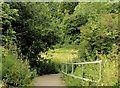
Path, Monkstown, Newtownabbey
A path leading down to this footbridge Image
Image: © Albert Bridge
Taken: 10 Aug 2012
0.16 miles
4
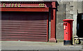
Pillar box BT37 805, Monkstown, Newtownabbey
EIIR pillar box (BT37 805) outside “Andy’s Stores” on the Monkstown Road.
Image: © Albert Bridge
Taken: 15 Jun 2014
0.17 miles
5
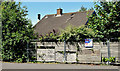
Vacant house, Monkstown, Newtownabbey (June 2014)
Another long-term vacant property, this one is on the Monkstown Road next to Monkstown Community School Image (out of picture to the left), probably awaiting redevelopment. It now has a wildly overgrown garden.
Image: © Albert Bridge
Taken: 15 Jun 2014
0.18 miles
6
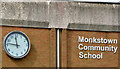
School clock, Monkstown, Newtownabbey
The clock on Monkstown Community School http://www.monkstowncommunityschool.org/, on the Monkstown Road, opposite Image
Image: © Albert Bridge
Taken: 16 Apr 2014
0.18 miles
7
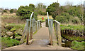
Footbridge, Monkstown, Newtownabbey
A footbridge across the Three Mile Water Image
Image: © Albert Bridge
Taken: 10 Aug 2012
0.19 miles
8
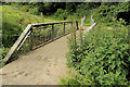
Squeeze stile, Monkstown
A squeeze stile at this bridge Image They come in many shapes and materials – for some other examples see Image Image Image and Image
Image: © Albert Bridge
Taken: 13 Mar 2014
0.19 miles
9
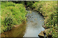
The Three Mile Water, Monkstown, Newtownabbey
The Three Mile Water, looking upstream, as it flows towards Whiteabbey Image
Image: © Albert Bridge
Taken: 10 Aug 2012
0.19 miles
10
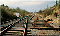
Realigned railway, Monkstown, Newtownabbey
The line from Bleach Green Jct to Antrim finally lost its passenger service in 1981 but remained as double track until eventually singled beyond Monkstown. This is the view, towards Antrim, at the start of the single-line section. The line from Monkstown to Bleach Green remained double with points controlled (at the time) remotely from a panel at York Road station. Passenger services have been restored but the line remains single.
Image: © Albert Bridge
Taken: 22 Apr 1986
0.20 miles