IMAGES TAKEN NEAR TO
Fernagh Court, NEWTOWNABBEY, BT37 0AR
Introduction
This page details the photographs taken nearby to Fernagh Court, BT37 0AR by members of the Geograph project.
The Geograph project started in 2005 with the aim of publishing, organising and preserving representative images for every square kilometre of Great Britain, Ireland and the Isle of Man.

There are currently over 7.5m images from over14,400 individuals and you can help contribute to the project by visiting https://www.geograph.org.uk
Image Map
Images are licensed for reuse under creativecommons.org/licenses/by-sa/2.0
Notes
- Clicking on the map will re-center to the selected point.
- The higher the marker number, the further away the image location is from the centre of the postcode.
Image Listing (22 Images Found)
Images are licensed for reuse under creativecommons.org/licenses/by-sa/2.0
Image
Details
Distance
1
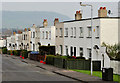
Fernagh Drive, Whiteabbey
Part of the eastern side of Fernagh Drive. The development dates from 1949/50 and was part of the “garden village” concept – see Image for an explanation. Knockagh monument Image is at middle top.
Image: © Albert Bridge
Taken: 15 Mar 2012
0.10 miles
2
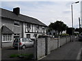
Ypres Park, Whiteabbey
Ypres Park in the Fernagh area of Whiteabbey. Evidently named after the Great War battle of the same name in which many locals participated. I'm not sure if these houses were intended for rehousing veterans.
Image: © Dean Molyneaux
Taken: 10 Jul 2009
0.13 miles
4
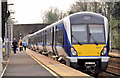
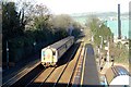
Train, Whiteabbey station (2012-1)
Three-cat C4K set (4003) calling at Whiteabbey with the 11.00 Carrickfergus – Belfast Central.
Image: © Albert Bridge
Taken: 15 Mar 2012
0.17 miles
5
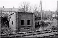
Old signal cabin, Whiteabbey
The base of the old signal cabin (since removed) beside the down line (laid with bullhead rail and wooden sleepers) at the Larne end of Whiteabbey station. It was closed when the line was re-signalled on the opening of the Bleach Green viaducts http://www.geograph.org.uk/snippet/6235.
Image: © Albert Bridge
Taken: 13 Feb 1982
0.17 miles
6
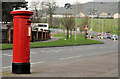
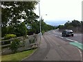
Pillar box, Cloughfern, Newtownabbey
GVIR pillar box (BT37 149) on the Station Road, near Cloughfern Corner (background).
Image: © Albert Bridge
Taken: 15 Mar 2012
0.18 miles
7
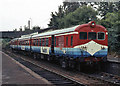
"Sealink" set at Whiteabbey - 1983
Northern Ireland Railways' "Sealink" liveried 70-class set pauses at Whiteabbey station with a Belfast - Larne Harbour passenger service. The origin of this colour scheme is explained: Image] . This set is believed last used in October 1985 and was scrapped in August 1986.
Image: © The Carlisle Kid
Taken: 18 Oct 1983
0.19 miles
8
Whiteabbey Station (2006)
A view of Whiteabbey Station made from the Station Rd bridge looking towards Bleach Green Junction.
Image: © Wilson Adams
Taken: 30 Dec 2006
0.19 miles
9
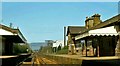
Whiteabbey station (1984)
Whiteabbey station opened in 1848. There was a substantial building on the up platform (right). When the photo was taken it was disused and blocked up awaiting demolition. The station was unstaffed although a conductor attended during the morning peak.
Image: © Albert Bridge
Taken: 24 Apr 1984
0.19 miles
10
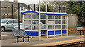
Shelter, Whiteabbey station
The passenger shelter, on the down platform at Whiteabbey station, is of the currently-standard NIR/Translink design Image The old style can be seen in Image (October 2004). The park and ride car park (background) opened in October 2009.
Image: © Albert Bridge
Taken: 15 Mar 2012
0.20 miles