IMAGES TAKEN NEAR TO
Mayfield Village, NEWTOWNABBEY, BT36 7WA
Introduction
This page details the photographs taken nearby to Mayfield Village, BT36 7WA by members of the Geograph project.
The Geograph project started in 2005 with the aim of publishing, organising and preserving representative images for every square kilometre of Great Britain, Ireland and the Isle of Man.

There are currently over 7.5m images from over14,400 individuals and you can help contribute to the project by visiting https://www.geograph.org.uk
Image Map
Images are licensed for reuse under creativecommons.org/licenses/by-sa/2.0
Notes
- Clicking on the map will re-center to the selected point.
- The higher the marker number, the further away the image location is from the centre of the postcode.
Image Listing (5 Images Found)
Images are licensed for reuse under creativecommons.org/licenses/by-sa/2.0
Image
Details
Distance
1
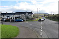
Road junction
Junction of Hydepark Road and the Hightown Road coming from the left. The Hydepark Road becomes the Upper Hightown Road beyond the junction.
Image: © Robert Ashby
Taken: 23 Oct 2014
0.16 miles
2
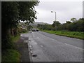
B95, Hydepark Road
Heading south-east
Image: © Kenneth Allen
Taken: 30 Sep 2009
0.18 miles
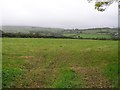
5
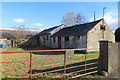
Old farmyard
Derelict looking farm buildings on the Upper Hightown Road.
Image: © Robert Ashby
Taken: 23 Oct 2014
0.25 miles